
CLARKSVILLE, TN (CLARKSVILLE NOW) – In geographic size, population, economy and culture, Clarksville has seen incredible changes during its 242-year history – with the bulk of those changes happening since the 1940s.
Thanks to Montgomery County Government’s Archives Department, we have several images of what we looked like back then. Clarksville Now’s Wesley Irvin recently went out to document the changes that have taken place since some of those photos were taken.
In recognition of America’s 250th anniversary, here are the 10 sets of photos from Clarksville then and Clarksville today. We’ve done our best to match the angles, but in some cases, either trees or drone airspace limitations got in the way.


1. Beachaven Vineyards and Winery
Beachaven Vineyards and Winery in the year of its grand opening, 1987, at 1100 Dunlop Lane. The winery was founded by former Montgomery County Executive (Mayor) William O. Beach. After his passing in 1991, it was owned and operated by his daughter, Louisa, and her husband Ed Cooke. Their son Wilson Cook is now operations manager.
(Original image: Montgomery County Archives, Clarksville Chamber of Commerce Collection, contributed. June 2026 image: Wesley Irvin, Clarksville Now)
| DON’T MISS A LOCAL STORY: Sign up for the free daily Clarksville Now email newsletter


2. Elder-Conroy Hardware Company building
The Elder Conroy-Hardware Company building at North First and Franklin Streets in 1935. The Elder Hardware Company began in 1867 under the leadership of the Elder brothers. In 1895, James Conroy came to work for the brothers and by 1899, the company had expanded to become the Elder-Conroy Hardware Company, according to the Montgomery County Archives. Originally, the store was in Public Square, however it was moved to Franklin Street in 1912. This building is now on the National Register of Historic Places.
(Original image: Montgomery County Archives, Kirk Photograph Collection, contributed. June 2026 image: Wesley Irvin, Clarksville Now)
| MORE: 10 people who changed Clarksville forever, from John Montgomery to Ted Crozier


3. Northwest High School
Northwest High School upon its opening in 1970. Northwest was built as a modern educational facility that would house 1,028 students, according to the Montgomery County Archives. Two complexes made up the original structure. One building housed administrative offices, traditional classrooms and the library, while the second housed the gymnasium and PE classes, as well as vocational programs.
(Original image: Montgomery County Archives, contributed. June 2026 image: Wesley Irvin, Clarksville Now)
| NEW TO CLARKSVILLE? Check out our Newcomer’s Guide


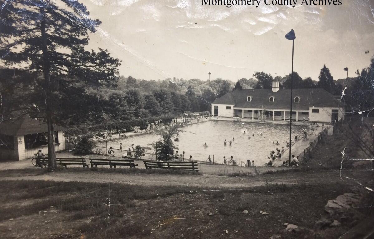
4. Dunbar Cave Swimming Pool
The Dunbar Cave Swimming Pool in 1935. In 1931, the pool opened as part of the resort development, according to the Montgomery County Archives. This concrete pool featured three diving boards, and a bathhouse was constructed next to it. By the late 1960s, waning popularity of the pool in favor of other city pools resulted in its closure and eventual filling-in. The old bathhouse is now the visitor center at what is now Dunbar Cave State Natural Area.
(Original image: Montgomery County Archives, Randy Rubel Collection, contributed. June 2026 image: Wesley Irvin, Clarksville Now)


5. Triangle Service Station and Cafe
The Triangle Service Station and the Triangle Cafe at the intersection of U.S. Highway 79 and 41A in the 1950s. The station offered 24-hour gas and oil services, while the cafe boasted homemade pies and plate lunches, according to the Montgomery County Archives. John “Red” Meacham was the owner and operator beginning in the early 1950s. The service station was a hub of activity for the community. Today, it’s long gone with the realignment of Dover Crossing, which now features several shops anchored by Kroger, in the background.
(Original image: Montgomery County Archives, Special Collections, contributed. June 2026 image: Wesley Irvin, Clarksville Now)
| BUSINESS OWNERS: Click here for a free consultation for advertising your business on Clarksville Now


6. Clarksville Plaza Shopping Center
The Clarksville Plaza Shopping Center in 1970, now Montgomery County Veterans Plaza. The shopping Center featured Montgomery Ward, Harvey’s Department Store and several other shops. Montgomery Ward closed around the same time the 1999 tornado went through Clarksville, and several county offices moved from downtown to the plaza. It’s now home to the Clarksville-Montgomery County Public Library, the County Archives, the Election Commission, Civic Hall, and several other county agencies.
(Original image: Montgomery County Archives, Leaf-Chronicle advertisement, contributed. June 2026 image: Wesley Irvin, Clarksville Now)
| MORE: Click here for more articles about Clarksville’s history


7. Austin Peay State College campus
An aerial view of Austin Peay State College in 1949, showing residential neighborhoods lining the opposite side of College Street. While the initial campus dates to 1845, it didn’t become Austin Peay Normal School until 1927, then APSC in 1943, and Austin Peay State University in 1966. Car dealerships and other businesses have sprung up along College Street over the years, and in the last decade APSU has been acquiring some of them for future growth.
(Original image: Montgomery County Archives, contributed. June 2026 image: Wesley Irvin, Clarksville Now)
| MORE: 11 women to remember as part of Clarksville history, from Stockade Annie to Faye Smalley


8. Franklin Street
A Christmas Parade along Franklin Street in the early 1930s. Prior to the development of such shopping meccas as Two Rivers Mall on Riverside Drive, the Clarksville Shopping Plaza on Madison Street, and of course Governor’s Square Mall years later, what we now call the “historic downtown” was the lifeblood of Clarksville retail.
(Original image: Montgomery County Archives, contributed. June 2026 image: Wesley Irvin, Clarksville Now)
| MORE: 10 worst disasters in Clarksville history, from Great Fire of 1878 to 2023 tornado


9. Trane Company
The Trane Company first entered into talks about establishing operations in Clarksville in October 1956 and within a year began construction of a manufacturing plant. The plant was built “out in the county” on Guthrie Highway. It’s now surrounded by stores and restaurants as part of Wilma Rudolph Boulevard, Clarksville’s busiest retail center.
(Original image: Montgomery County Archives, Clarksville Community Progress Program Scrapbook Collection, contributed. June 2026 image: Wesley Irvin, Clarksville Now)
| MORE: 10 Black leaders who helped to shape Clarksville’s future against all odds


10. Riverside Drive
There wasn’t much to Riverside Drive along the Cumberland River in the 1950s. But the roadway, formally designated U.S. Highway 41A Bypass, has since become home to Two Rivers Center, the Riverwalk and McGregor Park, the DoubleTree by Hilton Clarksville Riverview, and a string of shops and restaurants, with more to come.
(Original image: Randy Rubel collection, contributed. June 2026 image: Wesley Irvin, Clarksville Now)
| PREVIOUSLY:
- 10 worst disasters in Clarksville history, from Great Fire of 1878 to 2023 tornado
- 10 moments in history that made Clarksville what it is today, from tobacco heyday to St. B annexation
- 10 people who changed Clarksville forever, from John Montgomery to Ted Crozier
Sources: Montgomery County Archives, Leaf-Chronicle archives, Clarksville Now archives.