
Update, 3:10 p.m.: The Clarksville Jeep Crew has issued a statement saying their operations are conducted in close coordination with the Sheriff’s Office and the Police Department to ensure their efforts help, rather than hinder, official operations.
The CJC has assisted over 50 stranded vehicles Saturday as of 4 p.m. They also transported someone from a bus stop who had been waiting for over 45 minutes, unaware that the buses had stopped running.
Update, 2:45 p.m.: Snow has transitioned to sleet in downtown Clarksville.
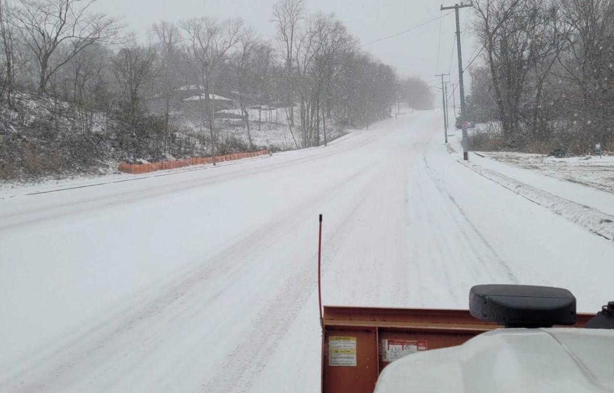
Update, 2:15 p.m.: Clarksville has about 2 inches of accumulation downtown so far, with snow still falling.


Update, 12:05 p.m.: Road conditions across Montgomery County are “deteriorating rapidly and becoming increasingly dangerous,” according to Highway Department officials. They are warning people to get off the roads, including volunteers trying to assist stranded vehicles.
“Extremely low temperatures are limiting the effectiveness of salt and brine treatments, allowing ice to form and refreeze quickly. Many roadways are already very slick, and conditions are continuing to worsen,” the county statement said.
“Our entire fleet of vehicles, as well as our city and state partners, are actively plowing and treating roadways, but continued public traffic is making it harder for crews to do their jobs safely and effectively. Even vehicles with four-wheel drive are losing traction, and we have already seen multiple vehicles slide off the roadway.
| MORE: For road conditions, click here for live Clarksville traffic cameras
“We understand the desire to help others, but additional traffic, including well-intended four-wheel-drive vehicles, is increasing risk and slowing emergency response and road treatment efforts. For your safety and the safety of our crews, please stay off the roads unless you are responding to an emergency or performing essential travel. Conditions are expected to remain hazardous.”
Previously:
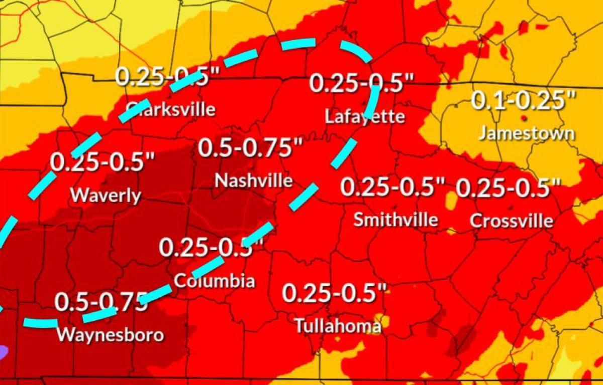
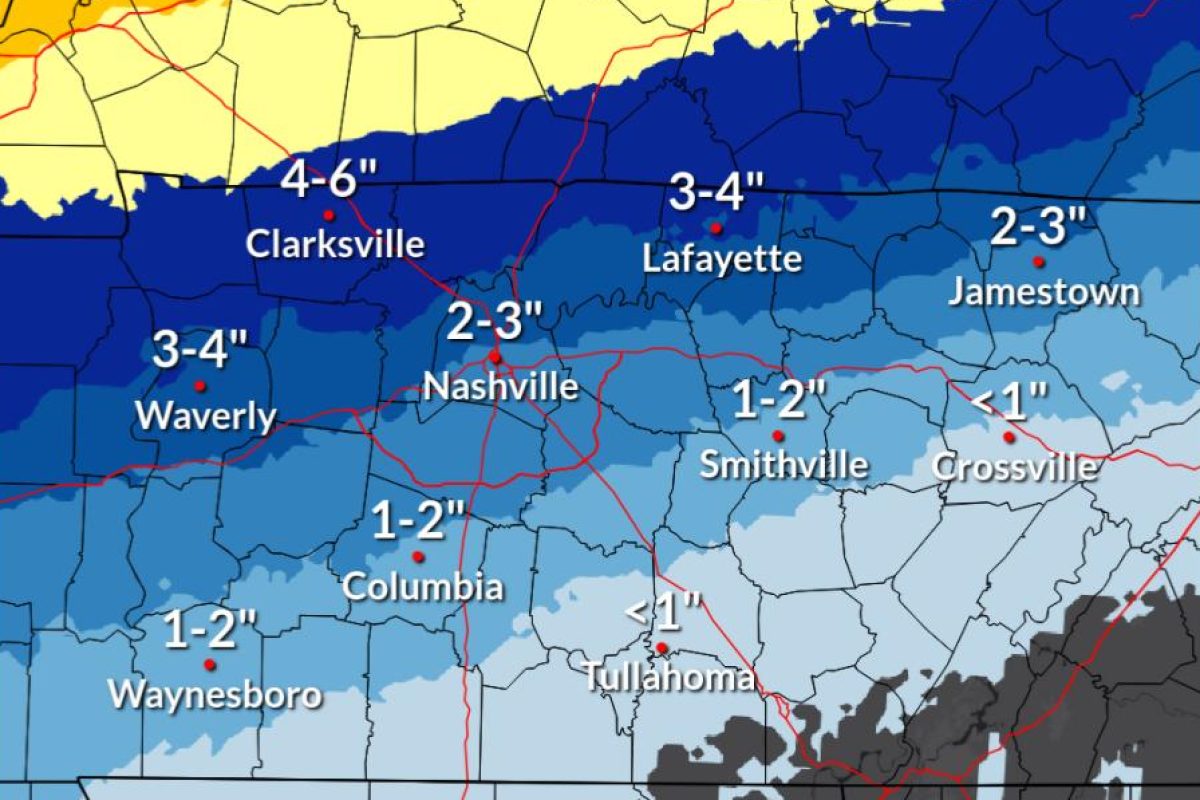
CLARKSVILLE, TN (CLARKSVILLE NOW) – The snow forecast has diminished a bit for Montgomery County while the risk of severe ice has increased. We’re expected to get a quarter-inch to a half-inch of ice, topped with 4-6 inches of snow by Sunday evening, according to the National Weather Service.
The light snow that had fallen as of 9:30 a.m. in Clarksville was dry and dusty, then heavy snow began around 10 a.m. It’s expected to mix with freezing rain and sleet Saturday afternoon and evening, followed by more snow on Sunday.
“Significant impacts are expected, including dangerous travel, potential power outages, and possible downed trees and branches,” the NWS said.
The NWS has issued a Winter Storm Warning for Montgomery and surrounding counties through 6 p.m. Sunday. Gov. Bill Lee has issued a State of Emergency for all 95 counties.
Winter storm timeline
Here’s what to expect as timing for our area, according to the NWS.
- Saturday afternoon/evening: Snow transitions to a mix of freezing rain and sleet.
- Saturday night/Sunday morning: Freezing rain/sleet mix.
- Sunday afternoon: Wintery mix transitions to snow.
- Sunday evening: Snow tapers off and bitterly cold air moves in.
| MORE: 7 most dangerous roads for winter weather wrecks in Clarksville
Clarksville forecast
Here’s the day-by-day outlook into next week.
- Today: Snow before 4pm, then snow, possibly mixed with sleet. The snow could be heavy at times. High near 22. Northeast wind 10 to 15 mph, with gusts as high as 20 mph. Chance of precipitation is 100%. Total daytime snow and sleet accumulation of 2 to 4 inches possible.
- Tonight: Snow, freezing rain, and sleet before 3am, then freezing rain and sleet. Low around 20. Northeast wind 5 to 10 mph. Chance of precipitation is 100%. New ice accumulation of 0.1 to 0.3 of an inch possible. New snow and sleet accumulation of less than a half inch possible.
- Sunday: Snow, freezing rain, and sleet before 1pm, then snow and sleet. High near 24. North northwest wind 10 to 15 mph, with gusts as high as 20 mph. Chance of precipitation is 100%. New ice accumulation of around a 0.1 of an inch possible. New snow and sleet accumulation of around an inch possible.
- Sunday Night: A 40 percent chance of snow before 11pm. Mostly cloudy, with a low around 6. Wind chill values as low as -4. North northwest wind around 10 mph, with gusts as high as 20 mph.
- Monday: Mostly sunny, with a high near 18. Northwest wind 5 to 10 mph.
- Monday Night: Mostly clear, with a low around -3. West northwest wind around 5 mph becoming south southwest after midnight.
- Tuesday: Sunny, with a high near 29. West southwest wind 5 to 10 mph, with gusts as high as 20 mph.
- Tuesday Night: Partly cloudy, with a low around 11. West southwest wind around 5 mph becoming calm in the evening.
- Wednesday: Mostly sunny, with a high near 30. Calm wind becoming west northwest around 5 mph in the morning.
- Wednesday Night: Mostly cloudy, with a low around 6.
- Thursday: Mostly sunny, with a high near 23.
- Thursday Night: Partly cloudy, with a low around 0.
- Friday: Partly sunny, with a high near 23.
| MORE: Winter weather: How to handle ice and snow in Clarksville