
Update, 3 p.m.: A Flood Watch has been issued for Montgomery and surrounding counties from Wednesday evening through Sunday morning. Several rounds of showers and thunderstorms are forecast, producing locally heavy rainfall across already saturated soils, the NWS said.
“Several inches of rain are possible, particularly across northwest Middle Tennessee,” the NWS said. “Confidence in flooding and flash flooding has increased in anticipation of these upcoming storms, and significant flooding could occur in areas of heaviest rainfall activity. This will be a multiple day flooding event which includes rises on area streams and rivers through the weekend.”
Previously:
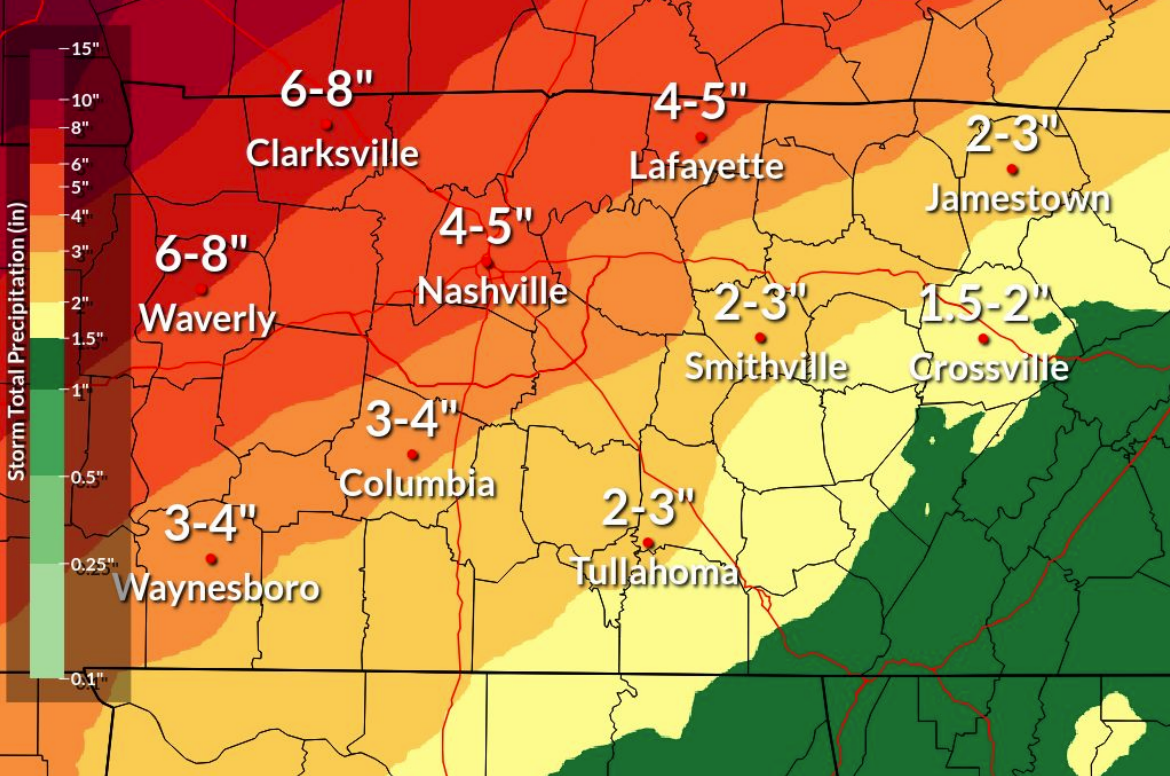
CLARKSVILLE, TN (CLARKSVILLE NOW) – With the ground already full of water, another round of storms is coming this week, bringing another 6-8 inches of rain to Clarksville.
A front will bring rain and thunderstorms Wednesday evening into Wednesday night, and some of the storms could be severe, according to the National Weather Service. All modes of severe weather will be possible, including large hail, damaging winds and tornadoes.
“The front will stall over the region and we will see periods of rain and thunderstorms Thursday into the weekend,” the NWS said. “Flooding will be a concern mid to late week with rises on rivers and creeks along with roadway flooding.”
Wednesday through Saturday, Clarksville is predicted to get 6-8 inches of rain, but that forecast is expected to shift as we get closer to the event. This weekend’s storm brought about .5 inches of rain, as recorded at Clarksville Regional Airport.
Clarksville forecast
Here’s the day-by-day outlook:
- Tuesday: Sunny, with a high near 67. East southeast wind 5 to 10 mph.
- Tuesday night: Increasing clouds, with a low around 56. East southeast wind 5 to 15 mph, with gusts as high as 25 mph.
- Wednesday: A chance of showers between 1pm and 4pm, then a chance of showers and thunderstorms after 4pm. Some of the storms could be severe. Partly sunny, with a high near 83. South wind 15 to 20 mph, with gusts as high as 35 mph. Chance of precipitation is 40%.
- Wednesday night: Showers and possibly a thunderstorm. Some of the storms could be severe. Low around 65. South wind 15 to 20 mph, with gusts as high as 30 mph. Chance of precipitation is 80%.
- Thursday: Showers and possibly a thunderstorm. Some of the storms could be severe. High near 77. South southwest wind around 10 mph, with gusts as high as 20 mph. Chance of precipitation is 80%.
- Thursday night: Showers and possibly a thunderstorm. Some of the storms could be severe. Low around 65. South wind around 10 mph. Chance of precipitation is 80%.
- Friday: Showers and possibly a thunderstorm. Some of the storms could be severe. High near 77. South southwest wind 5 to 10 mph. Chance of precipitation is 80%.
- Friday night: A 50 percent chance of showers and thunderstorms. Some of the storms could be severe. Mostly cloudy, with a low around 66.
- Saturday: Showers likely and possibly a thunderstorm. Some of the storms could be severe. Mostly cloudy, with a high near 78. Chance of precipitation is 70%.
- Saturday night: Showers and possibly a thunderstorm. Some of the storms could be severe and produce heavy rainfall. Low around 51. Chance of precipitation is 90%.
| WEATHER UPDATES: Click here for seven-day and hour-by-hour Clarksville weather forecasts