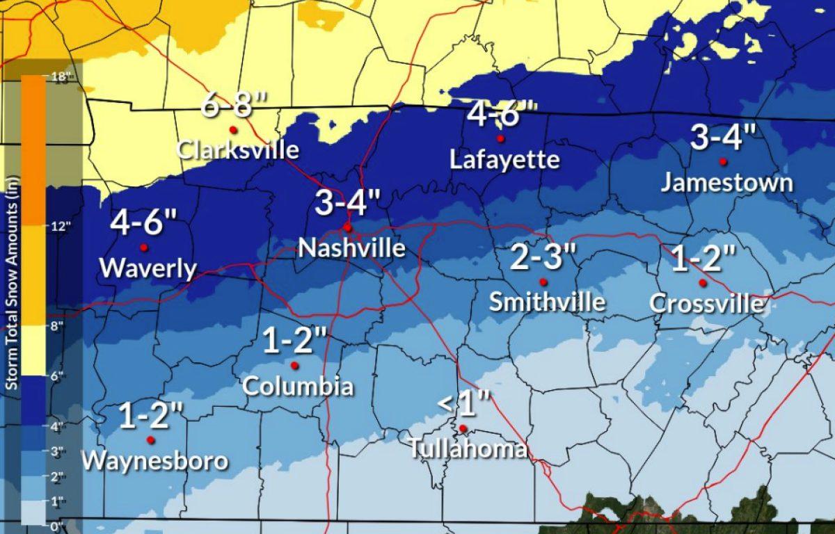

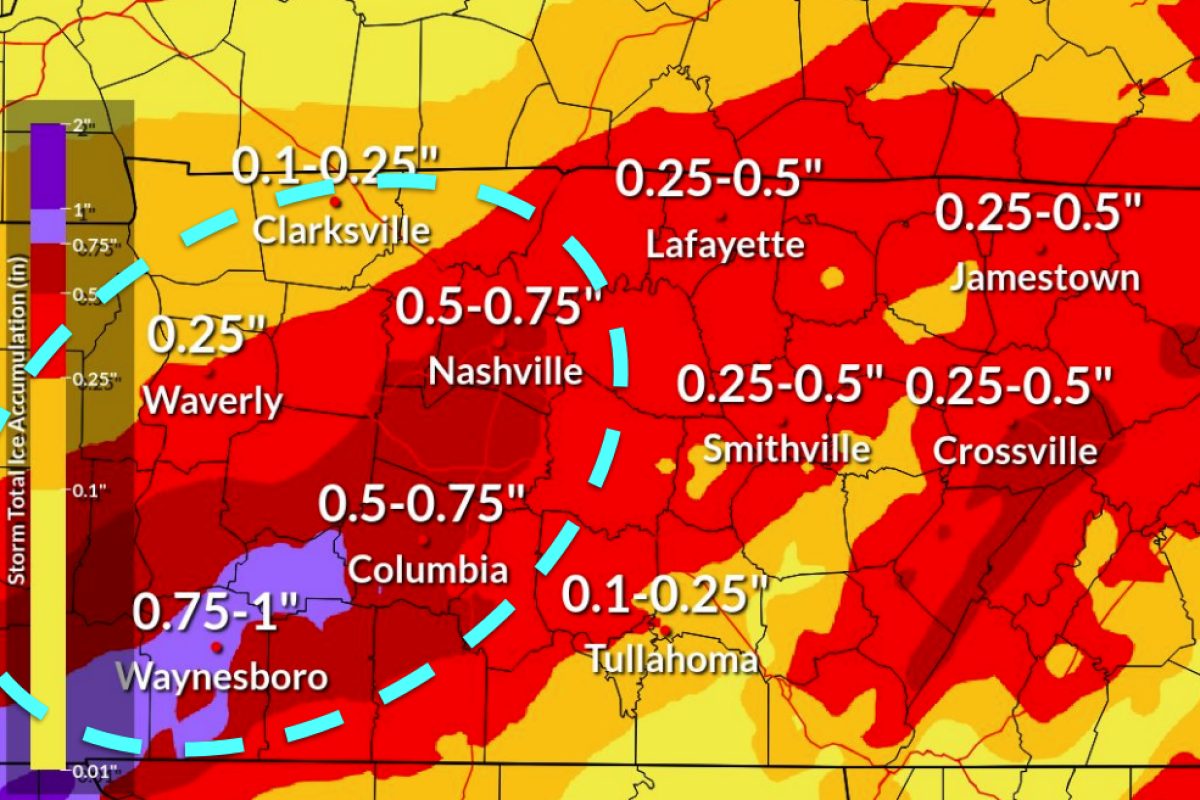
CLARKSVILLE, TN (CLARKSVILLE NOW) – Less than 24 hours out from the winter storm’s arrival, the latest forecast from the National Weather Service predicts Clarksville will get 6-8 inches of snow and 0.1 to 0.25 inches of ice.
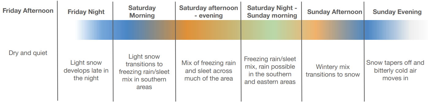
“Snow will mix with freezing rain, rain, and sleet Saturday afternoon into Sunday morning,” the NWS said. “Expect power outages and tree damage due to the ice. Travel could be impossible.”
The NWS has issued a Winter Storm Warning for Montgomery and surrounding counties from midnight Friday through 6 p.m. Sunday.
Gov. Bill Lee has issued a State of Emergency for all 95 counties and encouraged Tennesseans to prepare for a major winter storm.
Tennessee Department of Transportation (TDOT) teams are pretreating roadways and have replenished salt supplies in all 95 counties. When winter weather hits Tennessee, TDOT ice and snow removal teams focus first on clearing interstates and heavily traveled state routes, specifically targeting areas vulnerable to freezing, such as hills, curves, ramps, bridges, and interchanges, according to a state news release.
| MORE: Clarksville, Montgomery County prep for snow, ask residents to stay off streets
During prolonged weather events, crews may have to clear roadways repeatedly. Tennesseans should use caution and stay off the road unless travel is essential, and give TDOT crews and first responders room to work safely.
| MORE: For road conditions, click here for live Clarksville traffic cameras
| MORE: 7 most dangerous roads for winter weather wrecks in Clarksville
Clarksville forecast
Here’s the day-by-day outlook into next week.
- Saturday: Snow and sleet, with sleet possibly heavy at times. High near 23. Wind chill values as low as zero. Northeast wind 10 to 15 mph, with gusts up to 20 mph. Chance of precipitation is 100%. New snow and sleet accumulation of 2 to 4 inches possible.
- Saturday night: Freezing rain and sleet, possibly mixed with snow before 11 p.m., then freezing rain and sleet. Low around 17. Northeast wind 5 to 10 mph. Chance of precipitation is 100%.
- Sunday: Snow, freezing rain and sleet before noon, then snow likely, possibly mixed with sleet between noon and 3 p.m., then snow likely after 3 p.m. High near 25. Northwest wind around 10 mph, with gusts up to 20 mph. Chance of precipitation is 100%.
- Sunday night: A 30% chance of snow before midnight. Mostly cloudy with a low around 5. Northwest wind 5 to 10 mph.
- Monday: Mostly sunny with a high near 18. West-northwest wind 5 to 10 mph.
- Monday night: Mostly clear with a low around minus 1. West wind around 5 mph becoming south-southwest after midnight.
- Tuesday: Sunny with a high near 31. Southwest wind 5 to 10 mph.
- Tuesday night: Partly cloudy with a low around 12.
- Wednesday: Partly sunny with a high near 31.
- Wednesday night: Partly cloudy with a low around 7.
- Thursday: Mostly sunny with a high near 23.
| MORE: Winter weather: How to handle ice and snow in Clarksville
| MORE: Warming shelters open over weekend in Clarksville, volunteers needed