
Update 8:37 p.m.: Following the aftermath of today’s tornadoes, City Mayor Joe Pitts announces a state of emergency and public curfew.
“In accordance with Section 1-1204 of the Official City Code, and in light of the natural disaster occurring today, I am declaring the City of Clarksville to be under a State of Emergency. In furtherance of the State of Emergency, I find it is necessary for the health, safety, and welfare of the community to place the City under a Curfew for tonight (12/9) and tomorrow night (12/10) beginning at 9 p.m.”
(Video by Wesley Irvin)
Update, 7:04 p.m.: A Clarksville-Montgomery County spokesperson confirmed the deaths of three community members as a result of the tornado that touched down this afternoon, which included two adults and one child.
In addition, 23 people are being treated for injuries at the hospital, according to the news release. Clarksville-Montgomery County emergency services are still in the search and rescue phase of the disaster and will provide additional updates as they receive confirmation.


Mayor Wes Golden stated, “This is a sad day for our community. We are praying for those who are injured, lost loved ones, and lost their homes. This community pulls together like no other and we will be here until the end.”
“This is devastating news and our hearts are broken for the families of those who lost loved ones. The City stands ready to help them in their time of grief,” said City of Clarksville Mayor Joe Pitts.
Update, 7 p.m.: At this time we can confirm that three people are deceased, two adults and one child as a result of the tornado that touched down this afternoon. Additionally, 23 people have been treated at the hospital.
We are still in the search and rescue phase of this disaster and will provide updates as we receive confirmation.
(Video by Thomas Balzamo, contributed)
Mayor Wes Golden stated, “This is a sad day for our community. We are praying for those who are injured, lost loved ones, and lost their homes. This community pulls together like no other and we will be here until the end.”
“This is devastating news and our hearts are broken for the families of those who lost loved ones. The City stands ready to help them in their time of grief,” said City of Clarksville Mayor Joe Pitts.
Northeast High School located at 3701 Trenton Road is set-up as a Red Cross Shelter for anyone who has been displaced or in need of assistance.
It is vitally important that citizens avoid the area and stay off the roadway. The congested roadways restrict the movement of emergency vehicles.


Update, 5:15 p.m.: Manna Cafe has opened its shelter at 503 D Street if anyone needs a place to stay. Reminder: Northeast High School, 3701 Trenton Road, is the main shelter.
Grace Church of the Nazarene has canceled its Drive-Thru Nativity tonight.
Update, 4 p.m.: There are no reported fatalities or missing persons from today’s storm, according to Montgomery County Sheriff’s spokesman Sgt. Bishop Delaney.
The Hand Estates subdivision was hit hard by the storm, he said, and officials have searched the area to ensure everyone is OK. There are no totals available yet on injuries or on the number of homes damaged.
Update, 3:55 p.m.: A Clarksville woman and her children narrowly survived a tornado destroying their home Saturday afternoon.
“I looked out the window and saw debris flying,” Kassondra Adcock of 1927 Evans Road told Clarksville Now. “I jumped up and ran and got my kids and pushed them to my mother’s room. We prayed. The room that we were in was the only part of the house that didn’t get touched.”
The storm tore through their home, cutting it in half.
Shelter set up at Northeast High
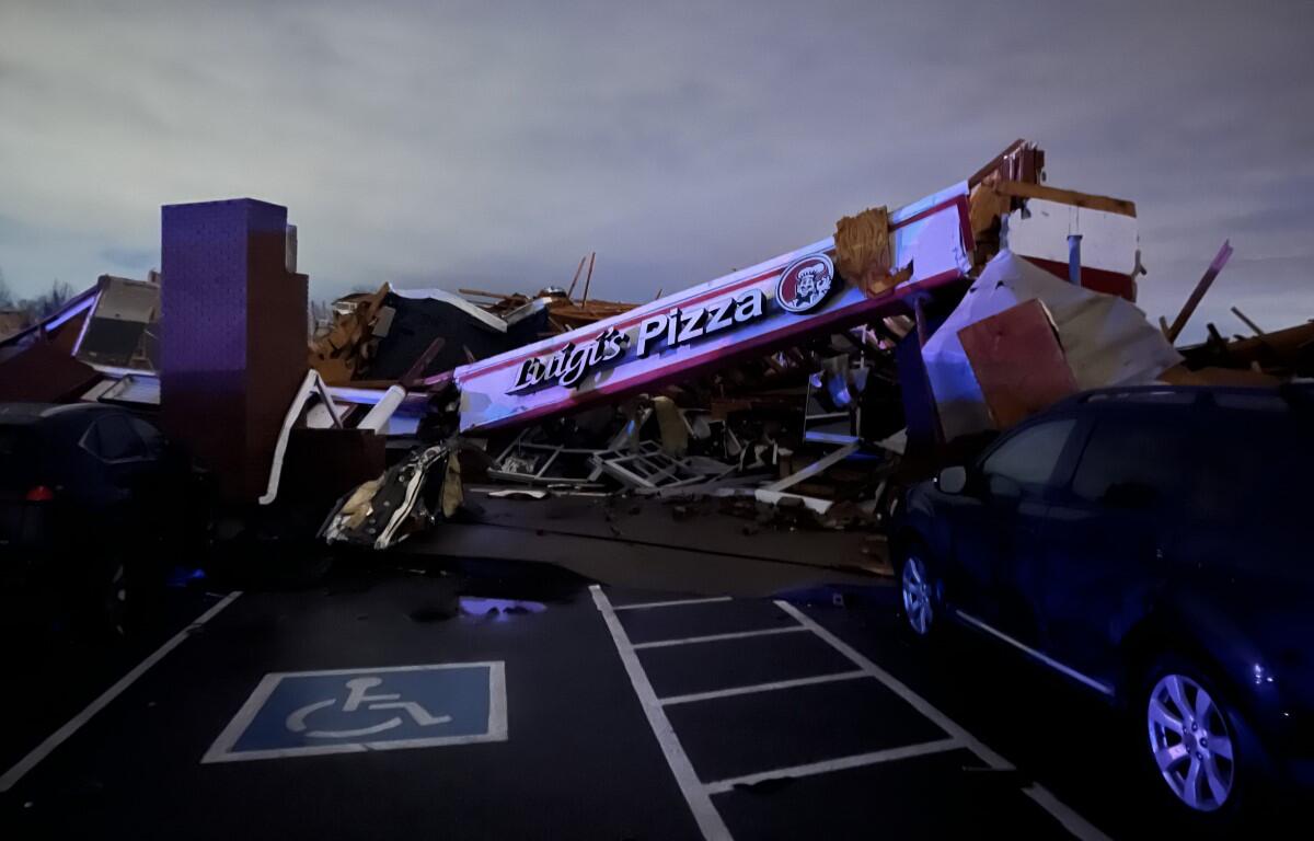
The Clarksville Police Department, Clarksville Fire Rescue, Montgomery County EMS are responding to numerous locations in the north Clarksville area due to the extensive damage from the tornado that touched down at approximately 1:35 p.m.
Mayor Joe Pitts and Chief David Crockarell are asking citizens to stay at home if possible and stay off the roadways, allowing emergency responders the room to operate.
Fort Campbell Boulevard is shut down at the 101st Airborne Division Parkway and traffic is being diverted onto the 101st.
Originally Pisgah Elementary was going to be a shelter, however, the school does not have power, and the shelter will be at Northeast High School.
(Video by Mikey Turner, contributed to Clarksville Now)
3:45 p.m.: The tornado warning for southeastern Montgomery County, plus parts of Dickson, Robertson and Cheatham counties, has been extended until 4:15 p.m.
3:20 p.m.: A new Tornado Warning has been issued for southeastern Montgomery County, plus parts of Dickson, Houston and Cheatham counties until 3:45 p.m.
At 3:18 p.m., a severe thunderstorm capable of producing a tornado was located 11 miles east of Erin, moving northeast at 40 mph.
3:10 p.m.: Pisgah Elementary School, 1770 Hazelwood Road, has been opened as a shelter for anyone who has storm damage, according to Clarksville Police spokesman Scott Beaubien.
There are several homes with damage in the northwest Clarksville area and roads are blocked by debris and emergency crews. Residents are urged to avoid the area while crews provide assistance.
Update, 2:10 p.m.: On Garrettsburg Road, one home was destroyed and another was damaged with people trapped inside, Montgomery County EMA Director Ed Baggett told Clarksville Now.
The NWS has confirmed that a tornado touched down in the Clarksville area.
“There is a confirmed tornado that has touched down in the Montgomery County area between Clarksville and Oak Grove, Kentucky,” said Britney Whiteheade with the NWS.
“We don’t know yet how strong that tornado was, but it was confirmed by both a spotter and also via radar.”

The Tornado Warning for Montgomery County has been canceled. A Tornado Watch remains in effect.
Update, 1:45 p.m.: A new Tornado Warning has been issued for northeastern Montgomery County until 2:15 p.m.
At 1:43 p.m., a severe thunderstorm capable of producing a tornado was located near Clarksville, moving east at 35 mph.
Update, 1:25 p.m.: A Tornado Warning has been issued for northwestern Montgomery County and east central Stewart County until 1:45 p.m.
At 1:22 p.m., a severe thunderstorm capable of producing a tornado was located near Big Rock, or near Dover, moving east at 35 mph.

“Flying debris will be dangerous to those caught without shelter. Mobile homes will be damaged or destroyed. Damage to roofs, windows, and vehicles will occur. Tree damage is likely,” the NWS said.
“Take cover now! Move to a basement or an interior room on the lowest floor of a sturdy building. Avoid windows. If you are outdoors, in a mobile home, or in a vehicle, move to the closest substantial shelter and protect yourself from flying debris.”
Update, 1:15 p.m.: A Severe Thunderstorm Warning has been issued for western Montgomery, northern Houston and Stewart Counties until 2:15 p.m.
At 1:11 p.m., severe thunderstorms were located along a line extending from 8 miles north of Big Rock to 6 miles southeast of Paris Landing State Park, moving east at 35 mph with possible 60 mph wind gusts and penny size hail.
“Expect damage to roofs, siding, and trees,” the NWS warning said. “For your protection move to an interior room on the lowest floor of a building.”
Previously:
CLARKSVILLE, TN (CLARKSVILLE NOW) – A Tornado Watch has been issued for Montgomery and surrounding counties through 7 p.m.
Strong to severe storms are expected this afternoon through this evening, according to the National Weather Service. If a tornado is spotted or indicated on radar, a Tornado Warning will be issued.
Damaging winds are the main threat, with tornadoes possible. Also, .5 to 1.5 inches of rain could be coming.
The storms are expected to reach Clarksville between 1 p.m. and 6 p.m.
ALERTS: For local severe weather alerts and updates, tune in to radio stations Beaver 100.3, Q108, Z97.5, Rewind 94.3 or NewZee 105.5.
Clarksville forecast
Here’s the rest of the weekend forecast.
Today: A chance of showers and thunderstorms, then showers and possibly a thunderstorm after 1pm. High near 67. South southwest wind around 15 mph becoming west in the afternoon. Winds could gust as high as 25 mph. Chance of precipitation is 100%. New rainfall amounts between a half and three quarters of an inch possible.
Tonight: Showers and thunderstorms likely before 10pm, then a slight chance of showers between 10pm and midnight. Mostly cloudy, with a low around 36. Northwest wind around 10 mph, with gusts as high as 20 mph. Chance of precipitation is 70%. New precipitation amounts between a tenth and quarter of an inch, except higher amounts possible in thunderstorms.
Sunday: Partly sunny, with a high near 43. Northwest wind around 10 mph.
Sunday night: Mostly clear, with a low around 25. Northwest wind 5 to 10 mph.
Wesley Irvin, Lee Erwin and Christian Brown contributed to this report.