
Update, 5:30 p.m.: Fort Campbell’s Gate 7 has reopened to non-commercial traffic. Outbound traffic is fully operational. Inbound traffic lanes are being rerouted into the commercial traffic lane to avoid the remaining standing water.
Update, 4:35 p.m.: The U.S. Army Corps of Engineers Nashville District is monitoring water levels on the Cumberland River and said locks and dams throughout the basin are performing as designed, controlling water levels along the length of the river.
“We are working closely with our local and state partners to proactively communicate the water levels across the system and encourage the public to stay informed through local news, alerts and the National Weather Service,” said Lt. Col. Robert Green, USACE Nashville District commander. “We are managing a large amount of water through our projects designed to mitigate flooding and we strongly discourage the public from recreating in these areas at this time.”
Here are updated forecasts for key locations:
- Cumberland at Nashville, a peak stage of 40.5 feet is predicted early Friday morning (Action stage = 30.0 feet; Flood stage = 40.0 feet).
- Cumberland at Clarksville, a peak stage of 50.8 feet is predicted midday Friday (Action stage = 40.0 feet; Flood stage = 46.0 feet).
- Cumberland at Dover, a peak stage of 67.3 feet is predicted overnight Friday (Action stage = 62.0 feet; Flood stage = 66.0 feet).
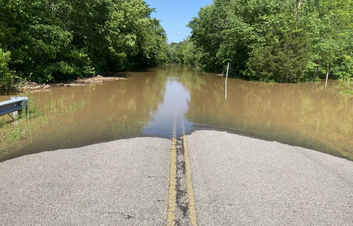
Update, 3:30 p.m.: At Dunbar Cave State Park, floodwaters have reached the edge of Dunbar Cave Road on one side and spilled over the Swan Lake embankment on the other.
Update, 10:50 a.m.: Major flooding is now expected for the Red River at Port Royal, with the Flood Warning extended until Saturday at 4 p.m.
The river is expected to a crest at 45 feet – 15 feet above the 30-foot flood stage – near midnight tonight. It will then fall below flood stage late Saturday morning, the NWS said.
At 44 feet, water reaches homes on Rivermont Drive, River Run, Idlewood Drive, and Wimbledon Court, and reaches yards of homes on Colin Court, East Accipiter Circle, Pond Apple Road, Foxfire Road, Hay Market Road, and Riverhaven Drive. Water reaches the Port Royal State Park Trail of Tears Trailhead parking area, and approaches yards of homes on Stonegate Drive and Willow Bend Drive.
At 46 feet, homes on Rivermont, River Run, Idlewood and Wimbledon are impacted and homes on Colin, East Accipiter, Pond Apple, Foxfire, Hay Market and Riverhaven begin to be impacted. Water reaches yards of homes on Stonegate and Willow Bend, and approaches Highway 161 near the Kentucky state line, Porters Chapel Road near Hugh Gill Road, and Highway 238 just north of the bridge at Port Royal State Park, which may be impassable at higher levels.


Update, 10:30 a.m.: A Flood Warning has been issued for the Cumberland River, which is expected to rise above the 46-feet flood stage Thursday afternoon to a crest of 51.4 feet early Friday afternoon.
At 50.0 feet, most agricultural areas along the river are flooded, as well as many industrial and commercial properties, McGregor Park, and adjacent tributaries. Riverside Drive begins to flood near Highway 48, Providence Boulevard, McClure Street and Cumberland Drive. Also impacted are locations near Quarry Road, Kraft Street near College Street and Providence Boulevard, Zinc Plant Road, Salem Road, and Seven Mile Ferry Road. Water approaches athletic fields near Greenland Farms Drive, and properties on Branch Road.
The river should fall below flood stage early Saturday afternoon.
The U.S. Army Corps of Engineers Nashville District said it is monitoring Cumberland River Basin conditions.
“Our flood storage projects are in a good position and performing as designed going into this weather event,” said Lt. Col. Robert Green, USACE Nashville District commander. “The district’s first priority is to safeguard life and property during any weather events. We will continue to monitor the situation and make operational adjustments as necessary.”
Update, 10 a.m.: The Clarksville Street Department has announced that, due to rising waters, Dunbar Cave Road is closed to thru-traffic between Idaho Springs Road and Warfield Boulevard. Water is projected to cover a portion of Dunbar Cave Road by or before 11 a.m. today. Only drivers who reside in that immediate area can use the road for now, according to a city news release.
The National Weather Service says most of Clarksville received 6 inches of rain, on already-saturated ground, during Wednesday’s severe storms and flash flooding. The Street Department is assessing flooded areas throughout the City of Clarksville.
Update, 9:30 a.m.: State Highway 12 in Montgomery County is on the list of state roads closed due to either flooding or storm debris, according to the Tennessee Department of Transportation.

Previously:
CLARKSVILLE, TN (CLARKSVILLE NOW) – Montgomery County was assaulted by storms carrying several rounds of hail and heavy rain on Wednesday.
From Wednesday morning through Thursday morning, we received 4.2 inches of rain, according to the gauge at Clarksville Regional Airport. The storms passed overnight, leaving behind a large sinkhole downtown, continued flooding along the Red River and hail damage to vehicles and homes.
Sinkhole next to Bypass
A large sinkhole has opened at the TDOT drainage easement near the Bypass/Cumberland Drive intersection at Gary Mathews Motors. Motorists are urged to use caution in this area as one eastbound lane is closed.
At Fort Campbell, Gate 7 was closed to non-commercial traffic Thursday morning due to standing water. The commercial lane will remain open to larger vehicles, but non-commercial traffic will have to go to another gate, according to a news release. The Gate 7 Visitor Control Center will remain open for those needing to obtain visitor passes in-person.
Flooding on Red River today
More flooding is expected. A Flood Warning has been issued for the Red River at Port Royal until late Friday evening.
The river is expected to a crest near 38.0 feet – 8 feet above the 30-foot flood stage – early Wednesday afternoon. It will then fall below flood stage early Friday afternoon.
At 38 feet, there will be significant flooding at the Red River Valley Park where several campsites will be flooded, Port Royal Road near Highway 238. Water will approach Dunbar Cave Road just west of Warfield Boulevard, and it may be impassable at higher levels, as water reaches low lying portions of the Swan Lake Golf Course, the NWS said.
Hail across Clarksville
At about 4:15 p.m. Wednesday, a storm of 2-inch hail pummeled Clarksville for close to 15 minutes. Golf-ball sized hail was reported in most cases, but some areas saw hail the size of baseballs.
The hail storm left parking lots of cars across Clarksville full of dent damage, with some reporting smashed windows.
To close or not to close?
Clarksville-Montgomery County Schools was opening on a two-hour delay on Thursday.
In response to concerns about CMCSS not closing early Wednesday, and students leaving school during Tornado Warnings, CMCSS said they closely monitored the incoming storms starting Tuesday night and got guidance on the storm’s severity and timing from the National Weather Service.
However, the timing of the storms changed quickly. “It takes around 3.5 to 4 hours to transport all students home on a typical school day, so by the time the storms began to intensify earlier than expected, an early dismissal was not an option,” the CMCSS statement said.
“We know not all families may have agreed with our decision to dismiss on regular schedule. Many families who had the option chose to pick up students early today. We also received appreciation from families who were working or otherwise could not be at home with children, who were glad their children could be in a safe place.”
DON’T MISS A STORY: Sign up for the free daily Clarksville Now email newsletter