
Update, 11:40 p.m.: A Flood Advisory has been issued for the Red River at Port Royal from tonight to early Wednesday morning.
At 10:30 p.m. Sunday, the stage was 25.9 feet and rising. The river is expected to rise above flood stage overnight to a crest of 35.1 feet early Monday afternoon. It will then fall below flood stage late Tuesday morning, the NWS said.
At 36 feet, flooding continues to affect agricultural land, parks, and access areas along the river, including the Red River Valley Park where water reaches campsites and evacuations may be needed, and Port Royal Rd near Hwy 238 which is covered with water. Water approaches Dunbar Cave Road just west of Warfield Boulevard and may be impassable at higher levels.
Update, 11 p.m.: At 10:58 p.m., Doppler radar was tracking strong thunderstorms along a line extending from Clarksville to Paris Landing State Park. Movement was southeast at 30 mph.
We remain under a Tornado Watch and a Flood Watch.
Update, 10:43 p.m.: At 10:40 p.m., severe thunderstorms were located along a line extending from Adairville, Kentucky to near Clarksville to near Paris Landing State Park, moving southeast at 40 mph.
CDE Lightband currently has 2,200 customers without power. Crews will continue to work through the night, CDE said.
Update, 10:02 p.m.: A Severe Thunderstorm Warning has been issued for Montgomery and surrounding counties until 11 p.m.
At 9:59 p.m., severe thunderstorms were located along a line extending from Lewisburg, Kentucky to near the Land Between the Lakes, moving southeast at 40 mph. Potential hazards include 60 mph wind gusts and quarter size hail.

Update, 9:43 p.m.: A Tornado Watch has been issued for Montgomery and surrounding counties until 5 a.m. A Watch from the National Weather Service means that conditions are right for a tornado to form at any time. If a tornado is spotted or indicated on radar, a Warning will be issued.
Update, 4:20 p.m.: Things are clear for now, but another round of storms is expected at about 9 p.m. in Clarksville. The main threat is straight line winds, but hail, tornadoes and flooding will also be possible.
Update, 3:45 p.m.: CDE Lightband is down to 3,100 customers without power, down from about 14,000 at the height of the storm.

Update, 1:18 p.m.: The Severe Thunderstorm Warning in Montgomery County has been extended to 2:15 p.m.
Flooding was reported in several areas this afternoon, including at the intersection of Riverside and Crossland Avenue.
Update, 12:04 p.m.: The National Weather Service has issued another Severe Thunderstorm Warning for Montgomery County until 12:45 p.m.
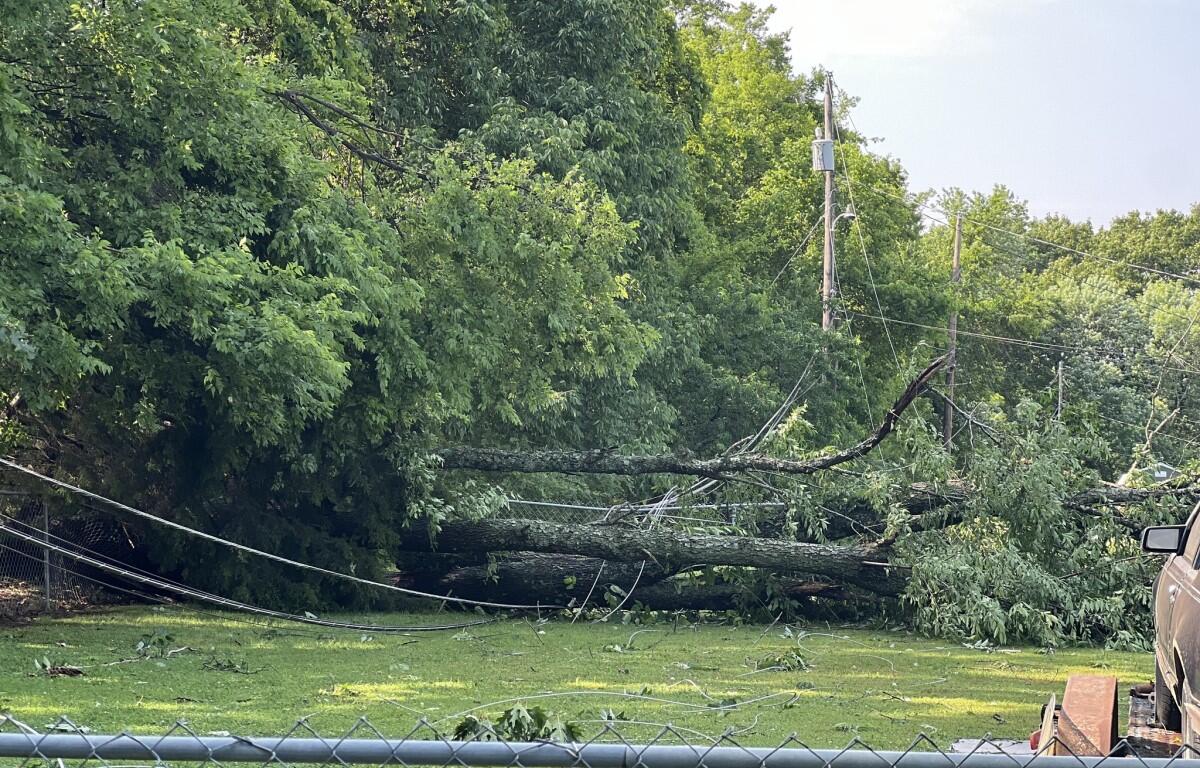
Update, 11:18 a.m.: The Montgomery County Sheriff’s Office confirmed a tree is blocking River Road around the area of Skyline Terrace. There have been some other roads that have minor blockages due to debris or small trees, but they are passable.
Update, 10:52 a.m.: First responders with the Clarksville Police Department, Clarksville Fire Rescue and the Montgomery County Sheriff’s Office are responding to numerous calls concerning power lines down, trees that have fallen and flooding. All of these events are causing traffic related issues and CPD recommends, if possible, for motorists to stay off the roadways.
CPD spokesperson Scott Beaubien said some roadways are impassable due to standing water. Meanwhile, the Street Department and CDE Lightband are working together to restore power while clearing debris from roadways. Here’s some other tips from CPD as the day progresses:
- Be cautious of standing water, you don’t know how deep it is and you may become stuck or worse.
- Watch out for downed power lines.
- Watch out for downed trees.
Updated, 10:32 a.m.: CDE Lightband has reported close to 14,000 customers without power.
Updated 9:41 a.m.: There is currently a Tornado Watch in effect for Montgomery County until 3 p.m., as well as a Severe Thunderstorm Warning in place until 10:00 a.m., according to the National Weather Service.
The radar indicated 60 mph wind gusts and nickel size hail in the area. Damage to roofs, siding, and trees is possible.
A fallen tree is reportedly blocking the roadway on Madison Street near Tenth Street, traffic will be affected in that area.
In other news, Sunday’s Spring Into Summer Activities have been canceled in Oak Grove due to the severe weather.

Previously:
CLARKSVILLE, TN (CLARKSVILLE NOW) – With heavy rain and storms expected today, a Flood Watch has been issued for Montgomery and most of Middle Tennessee through 7 a.m. Monday morning.
Excessive runoff may result in flooding of rivers, creeks, streams, and other low-lying and flood-prone locations, according to the National Weather Service.
We’re also at an “enhanced risk” of damaging winds of 60 mph or more, large hail, tornadoes and flash flooding, both today and tonight.
ON-AIR ALERTS: For local severe weather alerts and updates, tune in to radio stations Beaver 100.3, Q108, Z97.5, Rewind 94.3 or The Patriot 105.5.
Clarksville forecast
Here’s the day-by-day outlook.
- Today: Showers and possibly a thunderstorm before noon, then a chance of showers and thunderstorms, mainly between noon and 4pm. High near 88. South wind 5 to 15 mph, with gusts as high as 25 mph. Chance of precipitation is 80%. New rainfall amounts between a quarter and half of an inch possible.
- Tonight: Showers and thunderstorms, mainly before 3am. Some of the storms could produce heavy rainfall. Low around 69. South southwest wind 10 to 15 mph, with gusts as high as 25 mph. Chance of precipitation is 90%. New rainfall amounts between three quarters and one inch possible.
- Memorial Day: A 10 percent chance of showers and thunderstorms before 7am. Mostly sunny, with a high near 82. West wind around 10 mph, with gusts as high as 20 mph.
- Monday night: Mostly clear, with a low around 61. West northwest wind around 5 mph becoming calm in the evening.
- Tuesday: Sunny, with a high near 82. West northwest wind 5 to 10 mph, with gusts as high as 20 mph.
- Tuesday night: Mostly clear, with a low around 55. West northwest wind around 5 mph becoming calm in the evening.
- Wednesday: Sunny, with a high near 77. Calm wind becoming north northwest around 5 mph in the morning.
- Wednesday night: Mostly clear, with a low around 54. North wind around 5 mph becoming calm.
- Thursday: Sunny, with a high near 78. Calm wind becoming east northeast around 5 mph in the morning.
- Thursday night: Partly cloudy, with a low around 54.
- Friday: A 20 percent chance of showers. Mostly sunny, with a high near 80.
- Friday night: A 30 percent chance of showers and thunderstorms. Partly cloudy, with a low around 60.
WEATHER UPDATES: Click here for seven-day and hour-by-hour Clarksville weather forecasts
Christian Brown, Jordan Renfro and Daynnah Carmona contributed to this report.