
Update, 10:40 p.m.: All CMCSS schools will operate on a two-hour delay on Thursday. “With the expected strong storms, additional rain, and flooding overnight, the delay will provide additional time to ensure buildings are operational, and it will improve visibility for the morning commute. We will update families early tomorrow morning if there is a need for an additional delay or closure,” CMCSS said in an announcement
Clarksville Academy will open on a two-hour delay on Thursday.
Update, 8:05 p.m.: A Flood Warning has been issued for the Red River at Port Royal, affecting Montgomery and Robertson counties. Minor flooding is forecast, with the crest approaching moderate flood stage, until late Friday evening.
At 7:30 p.m., the stage was 25 feet and rising, the NWS said. Flood stage is 30 feet. The river is expected to rise above flood stage late this evening to a crest near 38.0 feet early tomorrow
afternoon. It will then fall below flood stage early Friday afternoon.
At 38 feet, significant flooding will impact agricultural land, parks, and access areas along the river, including the Red River Valley Park where several campsites will be flooded, and Port Royal Road near Highway 238 which will be covered with water. Water will approach Dunbar Cave Road just west of Warfield Boulevard, and it may be impassable at higher levels, as water reaches low lying portions of the Swan Lake Golf Course, the NWS said.
ON-AIR ALERTS: For local severe weather alerts and updates, tune in to radio stations Beaver 100.3, Q108, Z97.5, Rewind 94.3 or The Patriot 105.5.
The Tornado Watch for Clarksville has been extended until overnight, at 3 a.m. Thursday.
Update, 7:45 p.m.: Clarksville-Montgomery County Schools will open on a two-hour delay on Thursday, in anticipation of additional storms overnight. Families will be updated early Thursday morning of any additional delay or closure, according to a CMCSS announcement.
In response to concerns about CMCSS not closing early Wednesday, and students leaving school during Tornado Warnings, CMCSS said this:
“All students have been transported home. We cannot reiterate enough our appreciation for your patience and understanding today. Thank you to our bus drivers and Transportation Department for working diligently to transport students home during this severe weather. Thank you to our faculty, staff, and administrators who stayed late to ensure students were safe at school until they could get home. Thank you to our families for adjusting plans and for the many who jumped in to support schools as we sheltered in place together this afternoon.
Video contributed by Whitney Wallace
“Our Operations Department continuously monitors the weather. From our briefings with the National Weather Service around 9 p.m. last evening and again at 3 a.m. this morning, the main concern was for the line of storms that will move in later tonight and overnight. Based on that guidance from the National Weather Service, leadership discussed early this morning that we would not make any operational changes but would remain on high alert, closely monitoring the weather if we needed to make any shifts. Weather changes quickly, and we needed to make several shifts this afternoon. It takes around 3.5 to 4 hours to transport all students home on a typical school day, so by the time the storms began to intensify earlier than expected, an early dismissal was not an option. We know not all families may have agreed with our decision to dismiss on regular schedule. Many families who had the option chose to pick up students early today. We also received appreciation from families who were working or otherwise could not be at home with children, who were glad their children could be in a safe place. Please know that safety will always be our top priority, and we will always strive to make the best decision based on the information we have at the time.
NEWS ALERTS: To get free breaking news alerts on your phone, text the word NEWS to 43414.
“We value the feedback we have received from families today, both appreciation and concern. It has been a challenging day with this unusual outbreak of so many storms. After the devastation and tragedy our community experienced in December, we have heard from several families who expressed their sense of safety with the structural integrity of our facilities compared to their homes. We observed this with the damage in December and were reassured about the designated safe areas in our buildings.
“There is the potential for a long night for our community. As we saw in a National Weather Service briefing, “don’t be scared, just be prepared.” Ensure your family knows your severe weather plans and stay tuned to the latest weather updates. Please stay safe and alert!”
Update, 5:45 p.m.: Things have begun to calm down for now in Clarksville. Here are the current alerts for Montgomery County:
- Severe Thunderstorm Warning until 6 p.m.
- Tornado Watch until 9 p.m.
- Flash Flood Warning until 7:15 p.m.
- Flood Watch until 7 a.m. Thursday.
Update, 4:50 p.m.: A new Tornado Warning has been issued for northwestern Dickson County, south central Montgomery County and northeastern Houston County until 5:15 p.m.
At 4:49 p.m., a a severe thunderstorm capable of producing a tornado was located 7 miles east of Erin, moving east at 15 mph.
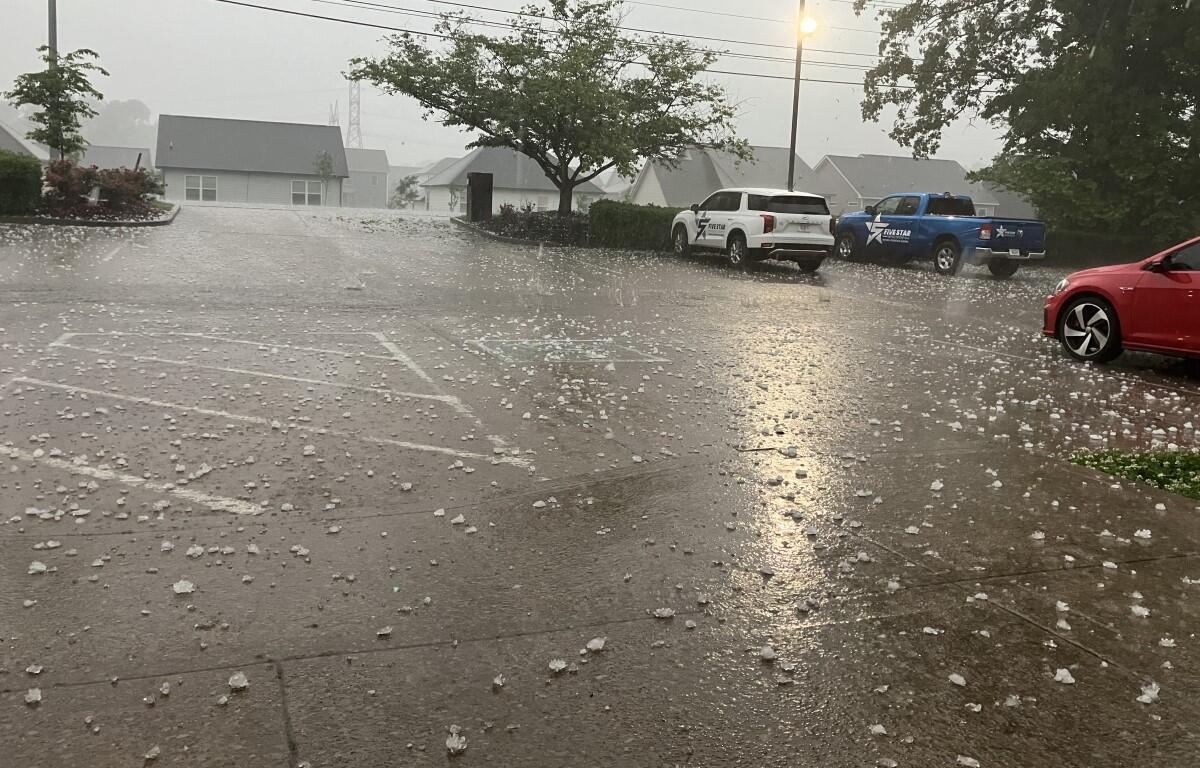
Update, 4:25 p.m.: Clarksville was just hit with 2-inch hail that has caused dent damage to vehicles.
Rounding things up, here are the current alerts for Montgomery County:
- Severe Thunderstorm Warning until 5:15 p.m.
- Tornado Watch until 9 p.m.
- Flash Flood Warning until 7:15 p.m.
- Flood Watch until 7 a.m. Thursday.
Update, 3:52 p.m.: A new Severe Thunderstorm Warning has been issued for Montgomery County until 4:30 p.m.
At 3:51 p.m., a severe thunderstorm was located 12 miles southwest of Clarksville, moving northeast at 40 mph with possible 60 mph wind gusts and quarter size hail.
Update, 3:43 p.m.: A Tornado Warning has been issued for northwestern Montgomery County and northeastern Stewart County until 4:30 p.m.
At 3:42 p.m., a severe thunderstorm capable of producing a tornado was located over Big Rock, or 8 miles northeast of Dover, moving east at 30 mph. This dangerous storm will be near Clarksville around 4:05 p.m.
Update, 3:33 p.m.: A Tornado Warning has been issued for Fort Campbell.
Update, 3:15 p.m.: A Tornado Warning has been issued for northern Stewart County until 4 p.m.
At 3:12 p.m., a severe thunderstorm capable of producing a tornado was located 7 miles northwest of Dover, or over the Land Between The Lakes, moving east at 30 mph.
Update, 2:50 p.m.: A new Tornado Warning has been issued for eastern Montgomery County and northern Robertson County until 3:15 p.m.
At 2:47 p.m., a confirmed tornado was located 7 miles northwest of Coopertown, or 10 miles west of Springfield, moving northeast at 30 mph.

Update, 2:35 p.m.: A Flash Flood Warning has been issued for Montgomery, Robertson and Cheatham County until 5:45 p.m. “Between 1 and 3 inches of rain have fallen. Flash flooding is ongoing or expected to begin shortly,” the NWS said.
A new Severe Thunderstorm Warning has been issued for eastern Montgomery County, north central Cheatham County, and northwestern Robertson County until 3:15 p.m. At 2:27 p.m., a severe thunderstorm was located 9 miles southeast of Clarksville, moving northeast at 30 mph with possible 60 mph wind gusts and quarter size hail.
Update, 2:07 p.m.: A Tornado Warning has been issued for Montgomery and Cheatham County through 2:30 p.m. A Warning means a tornado has been spotted. Seek shelter now.
At 2:06 p.m., radar indicated a severe thunderstorm capable of producing a tornado was located 10 miles south of Clarksville, moving northeast at 15 mph. The storm could produce a tornado and quarter-size hail.
“Flying debris will be dangerous to those caught without shelter. Mobile homes will be damaged or destroyed. Damage to roofs, windows, and vehicles will occur. Tree damage is likely.”
Other locations impacted by this tornadic thunderstorm include Cunningham and Palmyra. This includes Interstate 24 between mile markers 4 and 17.
Update, 2 p.m.: A Severe Thunderstorm Warning has been issued for Montgomery and nearby counties through 2:45 p.m.
At 1:58 p.m., a severe thunderstorm was located 11 miles southwest of Clarksville, moving northeast at 30 mph with possible 60 mph wind gusts and quarter-size hail. “Hail damage to vehicles is expected. Expect wind damage to roofs, siding, and trees,” the NWS said.
Update, 1:15 p.m.: A Tornado Watch has been issued for Montgomery and surrounding counties in Tennessee through 9 p.m. That includes Stewart, Houston, Dickson, Cheatham and Robertson counties.
A Tornado Watch from the National Weather Service means that conditions are ripe for a tornado to form. If a tornado is spotted or indicated on radar, a Tornado Warning will be issued.
Update, 8:35 a.m.: A Flash Flood Warning has been issued for Montgomery and Stewart counties until 11:45 a.m.
At 8:35 a.m., Doppler radar indicated thunderstorms producing heavy rain across the warned area. Between 1 and 3 inches of rain have fallen. Flash flooding is ongoing or expected to begin shortly, the NWS said.
“Expect flooding of small creeks and streams, urban areas, highways, streets and underpasses as well as other poor drainage and low-lying areas,” the alert said. “Turn around, don`t drown when encountering flooded roads. Most flood deaths occur in vehicles.”
Previously:
CLARKSVILLE, TN (CLARKSVILLE NOW) – Severe storms are moving across the Montgomery County area today, and they could bring flooding and tornadoes.
We can expect the severe thunderstorms in multiple rounds today and tonight, with another round overnight, according to a morning update from the National Weather Service.
The storms could bring damaging winds with gusts over 70 mph, large hail over 1.75 inches, tornadoes and flash flooding.
As of 8 a.m., between 1.5 and 2.5 inches of rain had already fallen. Additional rainfall amounts of 1 to 2 inches is expected. This additional rain will result in minor flooding. A Flood Watch is in effect through Thursday morning, and a Flood Advisory has been issued.
“Excessive runoff may result in flooding of rivers, creeks, streams and other low-lying and flood-prone locations,” the NWS said. “Flooding may occur in poor drainage and urban areas.”
Residents are encouraged to review their severe weather plans, and make sure they have chosen a safe place to take shelter.
ON-AIR ALERTS: For local severe weather alerts and updates, tune in to radio stations Beaver 100.3, Q108, Z97.5, Rewind 94.3 or The Patriot 105.5.