
Update, 7:47 p.m.: The Flash Flood Warning has been extended until 11 p.m.
Update, 4:48 p.m.: The Flash Flood Warning has been extended until 8 p.m. As of 4 p.m., 4.68 inches of rain have fallen.
Update, 2:03 p.m.: The Flash Flood Warning has been extended until 5 p.m. As of 2 p.m., 4.22 inches of rain have fallen in Clarksville since Wednesday.
Update, 1:45 p.m.: Montgomery County is under a Tornado Watch until 10 p.m. A Watch means that conditions are right for a tornado to form. If a tornado is spotted or indicated on radar, a Tornado Warning will be issued. That is usually preceded by a Severe Thunderstorm Warning.
Update, 12 p.m.: Montgomery County is under a Flash Flood Warning until 2 p.m.
Also, Flood Warnings have been issued for the Cumberland River at Clarksville and the Red River at Port Royal until 11:45 a.m. Tuesday.
| MORE: Cumberland River dams upstream from Clarksville holding back water to reduce flooding


Update, 11:30 a.m.: So far, the rainfall total in Clarksville since Wednesday is up to 3.38 inches.
Update, 10:50 a.m.: Severe thunderstorms are possible this afternoon and evening, and again Saturday evening. Friday will bring somewhat of a break with lower coverage of storms and lower risk levels. Today in Clarksville, there’s about a 25% chance of wind greater than 58 mph, a 40% chance of 1-inch or larger hail, and a 10% chance of a tornado.
Update, 10:31 a.m.: The Flood Advisory has been extended until 2 p.m. today. “The threat of flash flooding has ended, but some low lying and poor draining areas, as well as creeks and streams may still see high water into this afternoon as isolated storms move through the advisory area,” the NWS said. Driver are reminded to “turn around, don’t drown” when encountering flooded roads. Most flood deaths occur in vehicles.
CDE Lightband has about 270 customers without power. In Montgomery County, about 205 customers of CEMC are without power.
Update, 9:40 a.m.: CDE Lightband has about 340 customers without power. In Montgomery County, about 220 customers of CEMC are without power.
Update, 7:45 a.m.: CDE Lightband has about 380 customers without power, mainly in south Clarksville. In Montgomery County, about 820 customers of CEMC are without power.
Previously:
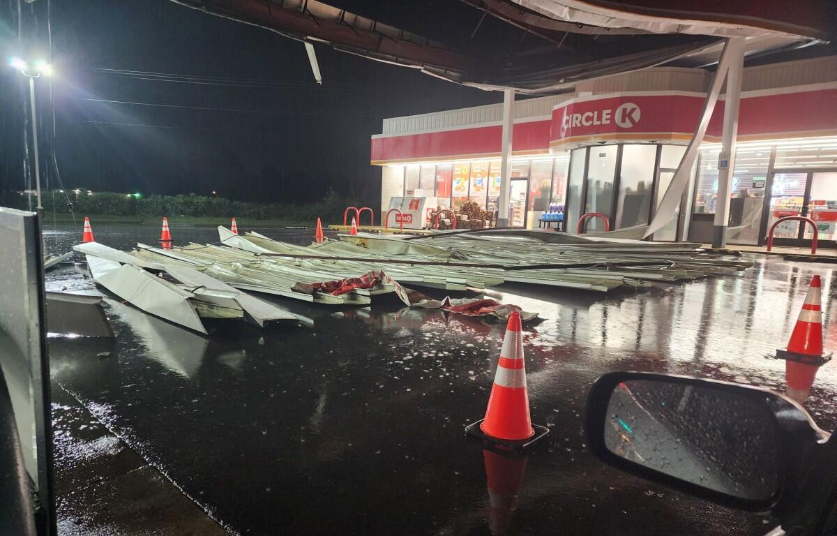
CLARKSVILLE, TN (CLARKSVILLE NOW) – Multiple trees and power lines were taken down by last night’s storm, including on the Bypass, Memorial Drive and Madison Street. But otherwise the storm passed over Clarksville with little damage.
Clarksville got 2.37 inches of rain overnight through 6 a.m., according to the official National Weather Service gauge at Outlaw Field, with more to come through Sunday. We remain under a Flash Flood Warning until 7:15 a.m., a Flood Advisory until 10:45 a.m., and a Flood Watch until 7 a.m. Sunday.
| MORE: Weather closings, delays: CMCSS closed, APSU going remote
| MORE: Street crews prepare for flooding and washouts, sandbags available
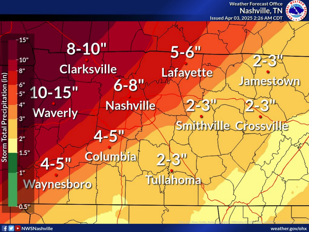
As for what’s next, the front will stall over Middle Tennessee and bring periods of heavy rain, the NWS said. “There is some uncertainty on where the front will set up and that will impact rain totals, but the highest rain totals are favored in the northwest.”
There is a risk for severe thunderstorms mainly today and Saturday. Damaging winds, large hail and tornadoes are all possible.
| LOCAL WEATHER: For Clarksville-specific weather updates, sign up for push alerts from our free Clarksville Now app
Clarksville forecast
Here’s the day-by-day outlook:
- Thursday: Showers and possibly a thunderstorm before 3pm, then showers and thunderstorms likely after 3pm. Some of the storms could be severe. High near 71. West wind 5 to 10 mph becoming east in the afternoon. Chance of precipitation is 90%. New rainfall amounts between 1 and 2 inches possible.
- Thursday Night: A chance of showers and thunderstorms, then showers likely and possibly a thunderstorm after 7pm. Some of the storms could be severe. Cloudy, with a low around 62. East northeast wind 5 to 10 mph becoming south after midnight. Chance of precipitation is 70%. New rainfall amounts between 1 and 2 inches possible.
- Friday: Showers likely and possibly a thunderstorm before 1pm, then a chance of showers and thunderstorms after 1pm. Cloudy, then gradually becoming mostly sunny, with a high near 83. South wind 5 to 10 mph, with gusts as high as 20 mph. Chance of precipitation is 60%.
- Friday Night: A 30 percent chance of showers and thunderstorms. Mostly cloudy, with a low around 69. South wind 10 to 15 mph, with gusts as high as 20 mph.
- Saturday: A chance of showers, then showers likely and possibly a thunderstorm after 1pm. Some of the storms could be severe. Mostly cloudy, with a high near 80. South wind 10 to 15 mph, with gusts as high as 25 mph. Chance of precipitation is 70%.
- Saturday Night: Showers and possibly a thunderstorm. Some of the storms could be severe and produce heavy rainfall. Low around 52. South southwest wind 10 to 15 mph becoming northwest after midnight. Winds could gust as high as 20 mph. Chance of precipitation is 100%.
- Sunday: A 50 percent chance of showers. Mostly cloudy, with a high near 60. North northwest wind around 10 mph, with gusts as high as 20 mph.
| WEATHER UPDATES: Click here for seven-day and hour-by-hour Clarksville weather forecasts