
Update, 10:30 p.m.: The Flash Flood Warning has been extended until 4:30 a.m. Sunday. As of 10 p.m., we have had 8.9 inches of rain this week, with more to come.
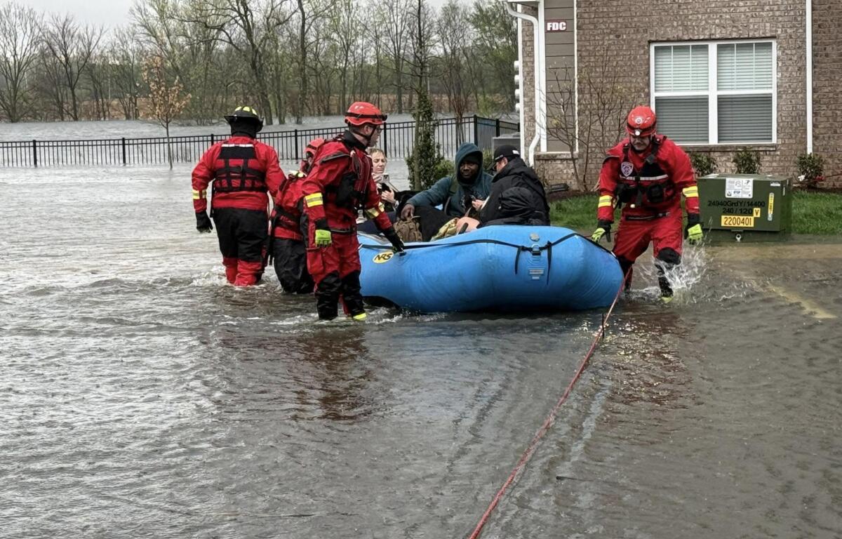
Update, 5 p.m.: About two dozen residents and their pets were evacuated this afternoon from at The Reserve at Kirkwood apartments as water continued to rise in the Dunlop Lane flood basin.
Montgomery County Fire Service crews evacuated buildings 1200 and 1300 due to water entering the buildings, according to resident Katherine Estrada.


The immediate concern was that there are underground utilities for the apartments, and CEMC had to pull the meter, MCFS Chief Michael Rios told Clarksville Now. They evacuated 22 people and several pets from 24 apartment units. One of the buildings was almost surrounded by water. Crews had to use a boat and rope system, as the water reached 5 feet deep in some places. The effort began around 1:30 p.m. and ended near 5 p.m.
Rios said they also rescued someone from a stranded truck near the complex. He urged people not to try to drive through water on roadways, as it’s one of the biggest dangers during flood situations.
The Flash Flood Warning has been extended until 10:30 p.m.


Update, 4:09 p.m.: A Severe Thunderstorm Warning has been issued for south Montgomery County until 4:30 p.m. A severe storm was located along a line extending from 6 miles east of Erin to 8 miles southwest of Dickson to 12 miles northeast of Linden, moving east at 60 mph with possible 60 mph wind gusts and quarter size hail.
Update, 3:55 p.m.: A new Severe Thunderstorm Warning has been issued for southeastern Montgomery County until 5 p.m. A severe storm was located 12 miles north of White Bluff, or 12 miles west of Ashland City, moving northeast at 50 mph with possible 60 mph wind gusts and penny size hail.
Update, 3:34 p.m.: A new Severe Thunderstorm Warning has been issued until 4 p.m. Severe storms were located along a line extending from 6 miles east of Vale to 10 miles southwest of New Johnsonville to Decaturville, moving east at 60 mph with possible 60 mph wind gusts and quarter size hail.
Update, 2:57 p.m. A Severe Thunderstorm Warning has been issued for all of Montgomery County until 4 p.m. A severe thunderstorm was located 10 miles west of Clarksville, moving east at 50 mph with possible 60 mph wind gusts and quarter size hail. Hail damage to vehicles is expected. Expect wind damage to roofs, siding and trees.
Update, 2:40 p.m.: A severe thunderstorm was located over Tennessee Ridge, or near Erin, moving northeast at 55 mph with possible 60 mph wind gusts and penny size hail.

Update, 2:23 p.m.: A Severe Thunderstorm Warning has been issued until 3 p.m. for western Montgomery County. A severe thunderstorm was located 7 miles east of Springville, or 12 miles north of Camden, moving east at 55 mph with possible 60 mph wind gusts and penny size hail. Expect damage to roofs, siding, and trees.
“Remain alert for a possible tornado,” the NWS said. “Tornadoes can develop quickly from severe thunderstorms. If you spot a tornado go at once into the basement or small central room in a sturdy structure.”
Update, 1:50 p.m.: A Tornado Watch has been issued for Montgomery County until 9 p.m.
Update, 1:20 p.m.: The Flash Flood Warning has been extended until 1:30 a.m. Sunday. As of 1:30 p.m., 6.83 inches of rain has fallen this week, and another 2-4 inches of rain is expected today.


Previously:
CLARKSVILLE, TN (CLARKSVILLE NOW) – We’ve had over 6 inches of rain in this week’s storms so far, and another 4-6 inches is on the way. The official National Weather Service gauge at Outlaw Field has recorded 6.58 inches of rain total for the week as of 9 a.m. Saturday.
While rain is likely all day, the severe storm should reach Clarksville between 2 and 5 p.m. We could get damaging winds up to 70 mph, Hail up to 2 inches, tornadoes and heavy rain.
Montgomery County is under a Flash Flood Warning until 3:30 today. We’re also under Flood Warning until Tuesday.
This article will be updated throughout the day.
| ROAD CLOSURES: Dunbar Cave Road, Dunlop Lane, Gholson Road and more
| RIVER FLOODING: Cumberland River, Red River expected to rise this evening, crest Sunday night
Clarksville forecast
Here’s the day-by-day outlook:
- Saturday: Showers and possibly a thunderstorm. Some of the storms could be severe and produce heavy rainfall. High near 75. Light and variable wind becoming south 5 to 10 mph in the morning. Winds could gust as high as 20 mph. Chance of precipitation is 90%. New rainfall amounts between 1 and 2 inches possible.
- Saturday night: Showers and possibly a thunderstorm. Some of the storms could be severe and produce heavy rainfall. Low around 50. North northeast wind around 10 mph, with gusts as high as 20 mph. Chance of precipitation is 90%. New rainfall amounts between 1 and 2 inches possible.
- Sunday: Showers likely and possibly a thunderstorm before noon, then a chance of showers between noon and 1pm, then a chance of showers and thunderstorms after 1pm. Cloudy, with a high near 55. North northeast wind around 10 mph, with gusts as high as 20 mph. Chance of precipitation is 70%. New rainfall amounts between a quarter and half of an inch possible.
- Sunday night: A slight chance of showers and thunderstorms before 7pm, then a slight chance of showers between 7pm and 1am. Mostly cloudy, with a low around 39. North wind 5 to 10 mph. Chance of precipitation is 20%.
| LOCAL WEATHER: For Clarksville-specific weather updates, sign up for push alerts from our free Clarksville Now app