

Update, 6:25 p.m.: The Tornado Watch for Montgomery County has been canceled.
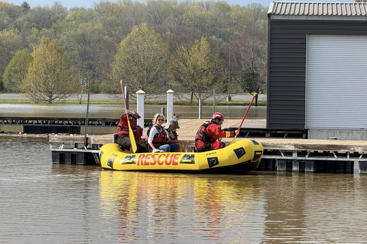
Update, 4:38 p.m.: A couple that tried to go boating on the Cumberland River had to be rescued by Clarksville Fire Rescue Friday afternoon.
They were headed upstream trying to get to Nashville, and their plan was to lock through Cheatham Dam, but the lock was closed, according to CFR. They turned back and were stranded at the Clarksville Marina docks, which are closed and surrounded by floodwater. CFR Squad 1, Ops 1 and the Swiftwater Team responded and rescued the couple.
Update, 2:55 p.m.: Montgomery County is under a Tornado Watch until 10 p.m. A Watch means that conditions are right for a tornado to form. If a tornado is spotted or indicated on radar, a Tornado Warning will be issued. That is usually preceded by a Severe Thunderstorm Warning. We remain under a Flood Warning as well.
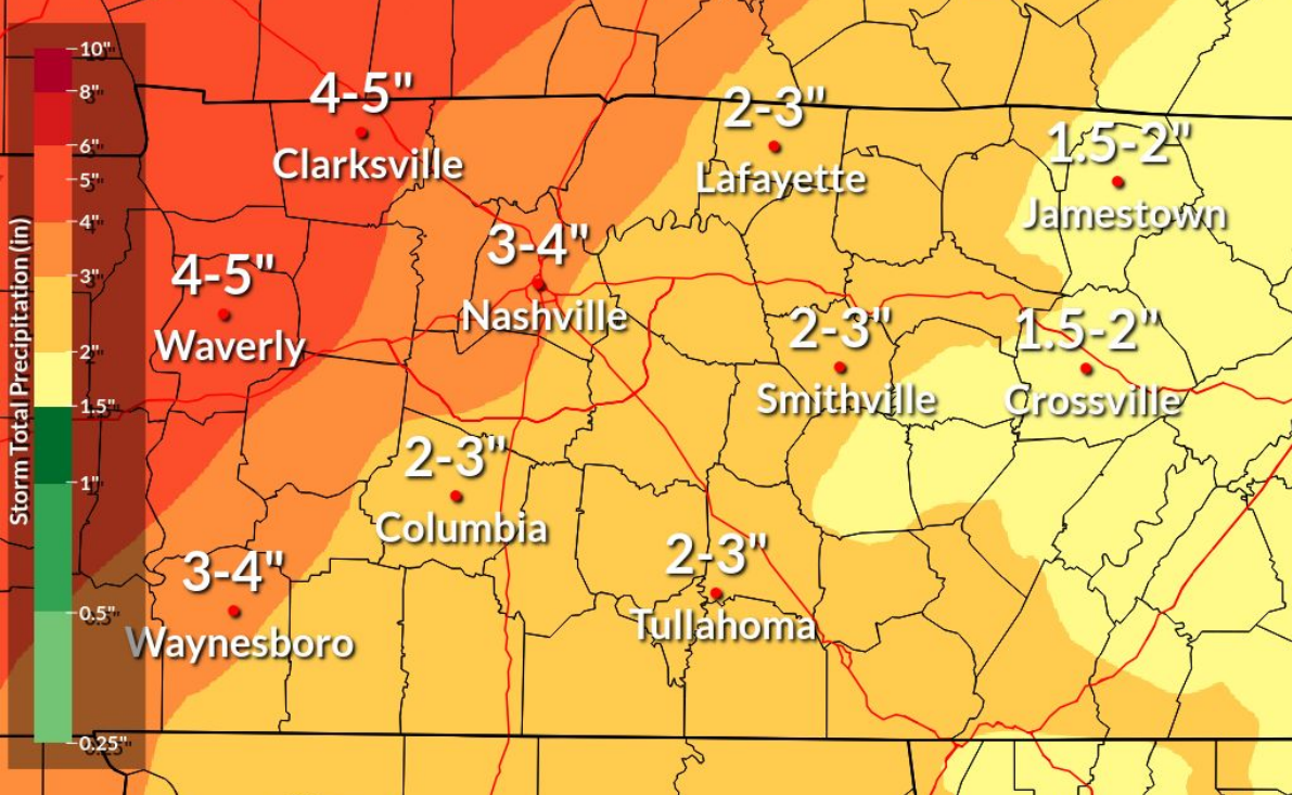
Update, 1 p.m.: The NWS has lowered their prediction to an additional 4-6 inches of rain through the weekend (graphic below updated). Saturday’s storm should reach Clarksville between 2 and 5 p.m.
| ROAD CLOSURES: Dunbar Cave Road closed, Dunlop Lane to close to install pump


Previously:
CLARKSVILLE, TN (CLARKSVILLE NOW) – We’ve had over 5 inches of rain in this week’s storms so far, and another 6-8 inches is on the way. The official National Weather Service gauge at Outlaw Field has recorded 5.25 inches of rain as of Friday morning.
Through the weekend, the highest rain totals will favor northwest Middle Tennessee, where additional rain amounts of 6-8 inches or more will result in flash flooding as well as river flooding, the NWS said. Clarksville remains under a Flood Warning until Tuesday afternoon.
| MORE: Cumberland River dams upstream from Clarksville holding back water to reduce flooding
Chance of storms
For Friday from about noon to 7 p.m., Clarksville has a slight chance of severe storms, with damaging winds up to 60 mph, hail up to 1 inch and heavy rain.
The more severe weather will come all day Saturday, with the worst of it 3-10 p.m. Plan for damaging winds up to 70 mph, Hail up to 2 inches, tornadoes and heavy rain.
| LOCAL WEATHER: For Clarksville-specific weather updates, sign up for push alerts from our free Clarksville Now app
Clarksville forecast
Here’s the day-by-day outlook:
- Friday: A chance of showers and thunderstorms before 1pm, then showers likely and possibly a thunderstorm between 1pm and 2pm, then a chance of showers and thunderstorms after 2pm. Partly sunny, with a high near 84. East wind 5 to 10 mph becoming south in the afternoon. Winds could gust as high as 20 mph. Chance of precipitation is 60%. New rainfall amounts between a tenth and quarter of an inch, except higher amounts possible in thunderstorms.
- Friday night: A 30 percent chance of showers and thunderstorms, mainly after 4am. Mostly cloudy, with a low around 67. South southeast wind 10 to 15 mph, with gusts as high as 20 mph.
- Saturday: A chance of showers and thunderstorms, then showers and possibly a thunderstorm after 2pm. Some of the storms could be severe and produce heavy rainfall. High near 77. South wind 10 to 15 mph, with gusts as high as 20 mph. Chance of precipitation is 80%. New rainfall amounts between 1 and 2 inches possible.
- Saturday night: Showers and possibly a thunderstorm. Some of the storms could be severe and produce heavy rainfall. Low around 48. North wind around 10 mph, with gusts as high as 20 mph. Chance of precipitation is 100%.
- Sunday: Showers likely and possibly a thunderstorm. Some of the storms could be severe. Mostly cloudy, with a high near 55. North northeast wind 10 to 15 mph, with gusts as high as 20 mph. Chance of precipitation is 70%.
- Sunday night: Mostly cloudy, with a low around 37. North wind 5 to 10 mph.
| WEATHER UPDATES: Click here for seven-day and hour-by-hour Clarksville weather forecasts