



8 p.m.: The Severe Thunderstorm Watch and Flash Flood Warning have both been lifted. Clarksville remains under an Extreme Heat Warning until Friday night, with a Heat Advisory through Saturday night.
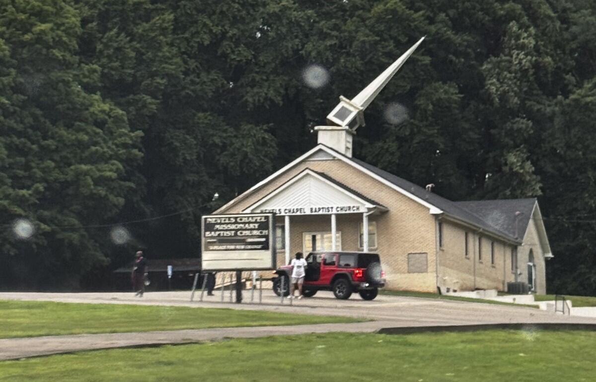
6:35 p.m.: Nevels Chapel Missionary Baptist Church on Martin Luther King Jr. Parkway had storm damage, with the spire broken off, according to a photo shared by reader Tina Ganus.
5:28 p.m.: A Flash Flood Warning has been issued for northern Montgomery County until 8:30 p.m. Doppler radar indicated thunderstorms producing heavy rain across the warned area. Between 1 and 3 inches of rain have fallen. Flash flooding is ongoing or expected to begin shortly. “Turn around, don’t drown when encountering flooded roads,” the NWS said. “Most flood deaths occur in vehicles.”
5:17 p.m.: Severe thunderstorms were located along a line extending from 8 miles southeast of Big Rock to near Erin to 8 miles southwest of Hurricane Mills, moving north at 10 mph with possible 60 mph wind gusts and nickel-size hail. The Warning has been extended to 6:15 p.m.
4:43 p.m.: The storm is now 7 miles southwest of Clarksville and is nearly stationary. The Warning has been extended to 5:30 p.m.
4:24 p.m.: A Severe Thunderstorm Warning has been issued until 5:15 p.m. for a storm located near Coopertown, or 11 miles north of Ashland City, moving northwest at 20 mph with possible 60 mph wind gusts and nickel-size hail. “For your protection move to an interior room on the lowest floor of a building.”
Update, 1:40 p.m.: A Severe Thunderstorm Watch has been issued for Montgomery and surrounding counties until 8 p.m. A Watch means that conditions are right for a severe storm to develop. If one is indicated on radar, a Warning will be issued.
Previously:
CLARKSVILLE, TN (CLARKSVILLE NOW) – Hot and humid weather will continue through the Independence Day weekend, with heat indexes climbing as high as 111 degrees and daily chances for afternoon and evening thunderstorms.
The Extreme Heat Warning from the National Weather Service remains in effect through 8 p.m. Friday. That will be replaced with a Heat Advisory through 8 p.m. Saturday.
“Dangerously hot conditions will continue through Independence Day with heat index values peaking in the 105 to 112 range,” the NWS said. Overnight lows will remain warm, only falling into the mid- to upper 70s, the NWS said. Some relief has become available in Clarksville with the opening of several cooling shelters.
Wednesday’s high reached 97 degrees at 4 p.m. at Clarksville Regional Airport, with a heat index of 107. That’s the highest point yet this year. Tuesday’s high was 94 with a 104 index. Monday was much the same. Sunday hit just under 92, with a 103 index.
Clarksville forecast
Here’s the day-by-day outlook.
Tonight: A 30% chance of showers and thunderstorms, mainly before 8 p.m. Partly cloudy, with a low around 75. East wind around 5 mph becoming calm.
Friday: A 30% chance of showers and thunderstorms, mainly between 1 p.m. and 3 p.m. Patchy fog before 7 a.m. Otherwise, sunny, with a high near 96. Heat index values as high as 111. Calm wind becoming northeast around 5 mph.
Friday night: A 20% chance of showers and thunderstorms before 1 a.m. Partly cloudy, with a low around 75. South wind around 5 mph becoming calm.
Independence Day: A slight chance of showers, then a chance of showers and thunderstorms after 10 a.m. Mostly sunny, with a high near 95. Calm wind becoming north northwest around 5 mph. Chance of precipitation is 30%.
Saturday night: A 30% chance of showers and thunderstorms before 1 a.m. Patchy fog between 2 a.m. and 3 a.m. Otherwise, partly cloudy, with a low around 74. Calm wind.
Sunday: A 40% chance of showers and thunderstorms after 1 p.m. Mostly sunny, with a high near 94. Calm wind becoming west southwest around 5 mph.
Sunday night: A 30% chance of showers and thunderstorms before 1 a.m. Partly cloudy, with a low around 74. Calm wind.
| WEATHER UPDATES: Click here for seven-day and hour-by-hour Clarksville weather forecasts