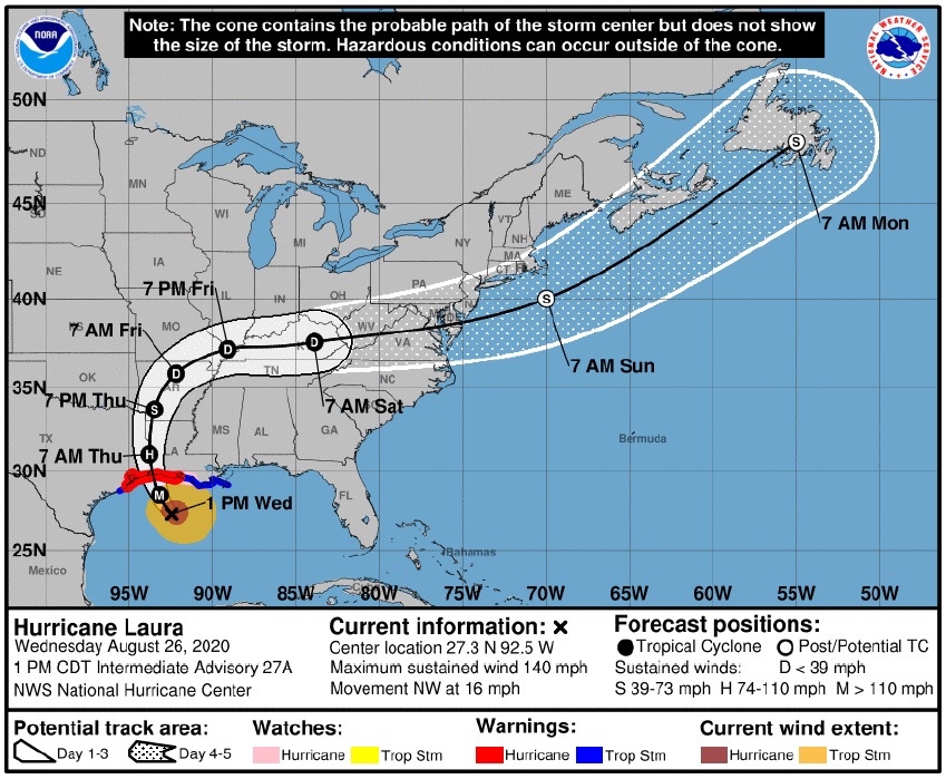

CLARKSVILLE, Tenn. (CLARKSVILLENOW) – The remnants of Hurricane Laura are now expected to bring up to 4 inches of rain, along with wind gusts of up to 40 mph, to Montgomery County.
“The hurricane will make landfall tonight along the Texas/Louisiana border and move northward through the day tomorrow before turning eastward toward our area on Friday,” the National Weather Service office in Nashville said Wednesday afternoon.
That means heavy rain Friday afternoon through early Saturday morning, from 1 inch to pockets up to 4 inches in the northwest, NWS reported. Meteorologist Mark Rose said the biggest threat from this weather event was going to be the heavy rain.
Quick, spin-up tornadoes are possible mid-afternoon Friday through midnight, and sustained winds of 15-25 mph with gusts to 40 mph Friday afternoon through early Saturday morning are expected.

Clarksville forecast
Here’s the rest of the forecast for the week.
- Tonight: Mostly cloudy. Lows in the lower 70s.
- Thursday: Mostly cloudy with a 20 percent chance of showers and thunderstorms. Highs in the upper 80s. Heat index readings 96 to 101.
- Thursday night: Mostly cloudy with a 40 percent chance of showers and thunderstorms. Lows in the mid 70s.
- Friday: Cloudy. Chance of showers and thunderstorms in the morning, then showers and thunderstorms likely in the afternoon. Locally heavy rainfall possible in the afternoon. Highs in the mid 80s. South winds 10 to 15 mph. Chance of precipitation 70 percent.
- Friday night: Showers and thunderstorms in the evening, then showers and thunderstorms likely after midnight. Locally heavy rainfall possible in the evening. Lows in the lower 70s. Southwest winds 10 to 15 mph. Chance of precipitation 80 percent.
- Saturday: Showers and thunderstorms likely. Highs in the mid 80s. Chance of precipitation 60 percent.
- Saturday night through Sunday night: Partly cloudy with a 20 percent chance of showers and thunderstorms. Lows in the mid 60s. Highs in the lower 80s.
- Monday through Tuesday: Mostly cloudy with a 50 percent chance of showers and thunderstorms. Highs in the mid 80s. Lows in the upper 60s.
- Tuesday night: Mostly cloudy in the evening then becoming partly cloudy. A 30 percent chance of showers and thunderstorms. Lows in the upper 60s.
- Wednesday: Partly cloudy with a 40 percent chance of showers and thunderstorms. Highs in the mid 80s.