
CLARKSVILLE, TN (CLARKSVILLE NOW) – Several homes across Clarksville suffered severe flooding this spring, ruining homes and property, and also raising questions: Who’s to blame for surges in stormwater, and what can be done about it? To address that, the City Council held a special work session recently to discuss drainage issues, clarify the city’s role, and talk about next steps.
However, a number of residents whose homes have been damaged said they aren’t satisfied with how the meeting played out.
Mayor Joe Pitts opened the Oct. 21 work session by saying this is just the first step in the process and labeled their drainage presentation an interim report. Pitts said his team has been meeting diligently to discuss every aspect of the challenges ahead, which includes the possibility of using local, state and federal resources to provide a lifeline to some neighborhoods in need, while proactively addressing future development to limit the impact of excessive water.
Two 100-year flood events
Street Department Director David Smith talked at the meeting about 100-year floods. “A 100-year flood is a flood that has a 1% chance of being equaled or exceeded in any given year. It’s also known as the base flood or 1% annual chance flood,” according to FEMA.
“That 100-year event that we talked about has a 1% chance (of happening), a 99% chance that it’s not going to happen. It happened twice in the month of May (2024) alone,” Smith said.
When comparing the total amount of rain Clarksville received in May this year to what it received back in 2010, data revealed Clarksville actually received more stormwater in 2024, totaling 15 inches of rain. “We got that much more rain in May of this year than what put Riverside Drive underwater (back in 2010),” Smith said.

Smith said with region’s karst topography, stormwater can migrate across the groundwater table, depending on the amount and how fast more flows in. “When the cave systems are full, there’s nowhere for this water to go; it saturates and rises above and out of those features,” Smith said.
Smith said the city has studied the problem in several affected spots around Clarksville, including:
- Cook Drive
- Hayes/Love
- Elberta/Freestone
- Danielle/Spees
- Vaughn Road
- Glenellen Landing
- Samantha Drive

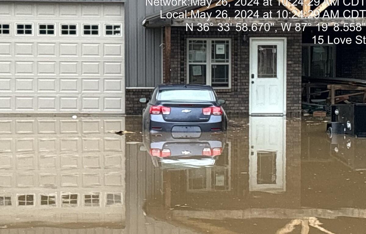
Hayes Street/Love Street
Clarksville Now previously spoke with William Lange and Danielle Luntz, who have dealt with their properties being flooded for more than four years now at the corner of Hayes and Love Street.
Smith said the lots have been legal lots since 1964, but they are now considered “legal nonconforming.” The properties sit at a low point where the stormwater is flowing from the subdivision. Their houses also sit across the street from a natural feature that has accepted stormwater for nearly 60 years, Smith said.
“It was there before this subdivision was constructed, it’s there today, and it still takes on that volume of water. Now, we’ve had some issues, we’ve had some flooding,” Smith said.
‘It wasn’t anything other than Mother Nature’
Smith referenced a picture that was taken of Luntz’s property being flooded, and said, “We get images like this that say, ‘My property’s flooded, the city has done something. What can the city do to help?’ … We have a small drainage easement that runs to the centralized portion of that feature.
“We know for 60 years this has ‘functioned.’ We know we experience around an acre of flooding that transverses this property (Lange’s) and the boundary of this property (Luntz’s). We see some standing water in those May 100-year events. The question was asked can we buy this lot (with the natural feature); can we manipulate this lot; can we improve the amount; can we retain water on this lot to help with flooding? The answer is probably,” Smith said.

“Let me qualify that. That qualify is probably about 10-15%. That’s about how much we can get in a compensatory cut. I’ve got to say, if that’s the approach, it’s a very dangerous approach. We have a naturally occurring feature that has functioned flawlessly for 60 years. If we manipulate that feature and cause it to collapse, cause it to compromise, were not dealing with an acre of flooding, we’re dealing with potentially dozens or even 100 acres of flooding in a standard 900-year rain event.”
Smith said the question remains does it merit going in and buying the lot. “If it collapses, can we repair it? Yes, to the tune of seven figures. So, that’s the question before the council, that’s not a decision I get to make.”
This was not a problem caused or created by the city, Smith said. “This was a development that was crafted in 1962. We annexed this property in the ’80s. We inherited this property when it was annexed. So, it wasn’t the development on the corner of Hayes and Love that caused this, it wasn’t anything other than Mother Nature and that groundwater table that we mentioned earlier.”
When 4 inches of rain came through after Hurricane Helene in 24 hours, there was no standing water on either Love Street property, Smith said. “That’s the system operating as it’s designed with a water table that’s not impacted because we didn’t just have a 100-year flood or any saturating rain that preceded it.”
‘Flaw in the design’
Lange responded to the city’s comments by saying, “When the ground gets saturated with more than 4 inches of water, that’s when the flooding shows up more frequently. … It would probably take 6 to 7 inches of continuous rain, not just in spurts. If it comes in spurts like Helene did … that’s not enough to show its face, and the flaw in the design that the city created. Even if we get 3 inches of rain in an hour, we’re fixing to flood.”
Lange said when they do receive continuous rain, most of the water that can’t be suppressed is coming from a nearby subdivision, as well as Covington Street and Pea Ridge Road. Then, that stormwater is led to the 18-inch pipe that sits near Lange’s property, which can be overwhelmed by the amount of water trying to pass through.
The Love Street homeowner said they did not inherit the problem; the city created the problem by diverting water.
Elberta Drive/Freestone Drive
Clarksville Now also previously spoke with longtime Clarksville resident Candace Payne, who had her property flood on Memorial Day, just to find out from surrounding neighbors that the property has flooded for decades.
The Elberta Drive development was built in 1966, before the National Flood Insurance Program and before FEMA. “The folks that said this development, these homes, were built substandard, they were built to the standard of the time. They were built honest,” Smith said.
Smith showed an estimated 2-D model of a 100-year flood plain in the area of Elberta Drive, and several homes are within that plain.

“Developing this and other features has taken a tremendous amount of time, survey work and transits on site to develop what this elevation is. … Now, the home I just referenced sits right here well within that. This is a 2-dimensional model, so just because the water traverses the area doesn’t mean the flooding level is above finished floor.
“In that same area shows the subdivision water flowing to the bottom of the neighborhood,” Smith said. “Again, TDEC standards, Tennessee law, natural flow rule. Everything is flowing, you can’t impede that, you can’t impact that. It has to flow to the lowest point.”
Smith said it was reported recently that the reason Elberta Drive flooded was because of a blocked storm drain. “I can promise you nothing is further from the truth. There is no blocked storm drain; there’s no storm drain out there. There is an injection well that assists with diverting some of the water and directs it to a seam, but again, this is the lowest point of this neighborhood. When it rains and the (ground) water table rises, this is underwater,” Smith said.
“The question was can we go out there and provide a compensatory cut. Could we cut through this area and provide ponding, if you will, or detain and retain water. The answer is yes, we can do that, but it’s the same threshold that we talked about with Hayes and Love Street. Once that water table comes up, it doesn’t matter how deep these holes we dig are, they’re full of water.”
Smith provided a graphic that showed the homes directly affected by what the city believes to be a 100-year flood map in that area. Residents have been sent a questionnaire to help the Street Department fill out some applications, according to Smith.
Why weren’t purchasers warned?
Councilperson Wanda Allen brought up that Payne wasn’t informed that her property had flooded for years, and she asked Smith why that isn’t something that is required to be disclosed.
“Legally, I can’t speak to that,” Smith said. “I feel that it should have been disclosed. … As Justin Crosby has mentioned, that’s a conversation with your Realtor – that’s a private transaction.”
Councilperson Stacey Streetman asked if there is a way an individual can reach out to the city through SeeClickFix, which is on the City of Clarksville’s website, to get this information.
“One of the women that came here and spoke, she wasn’t aware, she wasn’t told anything about any previous issues,” Streetman said. “Would there be a way that an individual can reach out through there and find out if there has been any reports of flooding on a certain property?”
Pitts said that’s something the city can discuss moving forward as they continue to discuss the challenges ahead.
NEWS TIPS: Do you have a local news tip? Email news@clarksvillenow.com or call us at 931-648-7720.
Payne said she was disappointed with the City Council’s special work session. “It seems as though the city is finding every way possible to avoid ownership and fault the residences for circumstances beyond our control. The city can try to point blame in every direction, but with Elberta Drive, the core issue is that the city has known of flooding issues on my street for decades, yet the house was still available for me to buy in 2020.”

Vaughn Road
Ronnie Howton bought his property on Vaughan Road near Exit 11 in 2014, and he’s been dealing with flooding issues ever since. He took to trying to divert the water, even into the city’s sewage system before being stopped.
Smith said Howton’s home has one-third of an acre that the U.S. Fish and Wildlife has designated as a protected wetland. “That designation means that this property seasonally floods,” Smith said.
This was another property that was outside the city limits when the home was built – in the 1980s – and became part of the city when the area was annexed.
“This property floods, and it floods exactly where U.S. Fish and Wildlife said it was designed to flood,” Smith said, sharing a map showing the flood area. “There’s a specific feature that is under this property, so this is an entire network of caves. … Again, it fills with water and when that water fills those, it evacuates through the throat, and you see it at the surface.”

Howton insisted to Clarksville Now that his property is not a wetland. He said the Tennessee Department of Environment and Conservation inspected the site and told him they don’t think the property is a wetland, and he is scheduling a visit by a representative with the Army Corps of Engineers to get their opinion as well. “If the state doesn’t contradict federal, then that’s two forms of proof my property has been misrepresented,” Howton said.
However, Smith told Clarksville Now that those opinions don’t change the official wetland designation, as U.S. Fish and Wildlife serves as the “big brother” in this scenario, since it is a federal agency.
He said US Fish and Wildlife designated the property as a protected wetland back in 1981. That, and someone building a home on the property despite the designation, may not have landed on TDEC’s radar.
FEMA could step in, have homes demolished
City Grants Director Lauren Winters works with TEMA and FEMA for both public assistance and hazard mitigation. She said the City has previously purchased homes and properties using FEMA’s Hazard Mitigation Grant Program (HMGP). TEMA administers this program for the state of Tennessee, and Clarksville submitted a notice of intent in July 2024 related to the May 2024 storms.
“We are in the process of completing the extensive applications to assist homeowners affected by recent flooding,” Winters said. “We have requested additional information from a set of affected homeowners to determine both their interest and eligibility.”
Winters said eligible proprieties must fit the following criteria:
- Have had three years of documented loss. Must include insurance, pictures, measurements, etc.
- Those three years must be under the current owner. However, if there is sufficient documentation from prior ownership, FEMA can utilize storm data, as well as that prior owner’s insurance claims and rejections.
- Elevation Certificate showing flood map. “This will require the city to pay FEMA to remap the areas as each of the properties we have looked at were not in a current FEMA-identified flood zone,” Winters said.
“Ultimately FEMA has the final say on which applications receive funding, even if they are considered eligible upon submission,” Winters said. “The city works directly with TEMA who then submits those projects to FEMA.”
DOWNLOAD THE APP: Sign up for our free Clarksville Now app
FEMA also looks at other cost-effective solutions such as elevating the home and placing drains. FEMA decides what it believes to be the value/reimbursable demolition cost, according to Winters.
If the property is purchased and buildings are demolished, the city has to take ownership of the property and use it for a non-building purpose, Winters said. “This can include drainage mitigation. The property would also have a deed restriction that it can never be built on. … FEMA pays 75% of the cost, and TEMA covers the remaining 12.5% of that 25% local share.”
But there’s a hitch:
“If you conduct FEMA flooding mapping, which is BCA requirement, and the property is determined to be in a FEMA flood zone, they will be required to get flood insurance,” Winters said. “This applies to any home within the flood map, not just the current affected property owners. This could mean currently unaffected property owners in the surrounding area would now find themselves in a FEMA-identified flood plain.
“This insurance is not a city requirement, rather, this would be a lender’s requirement for existing and new mortgages.”
The average annual premium for flood insurance in Tennessee is $991, depending on location, flood zone, value, design and age of structure, according to Winters.
How can you protect yourself?
Building and Codes Director Justin Crosby offered ways residents can protect themselves when looking to purchase a home:
- “Ask your Realtor or builder for a copy of the subdivision plat to look for drainage easements and retention areas.
- “Look over the plat with the Realtor and/or contractor. Be sure to ask questions about any easements or retention areas prior to closing.
- “Some older neighborhoods may not have easements shown on a plat. Look for features such as drainage ditches or potential retention areas.
- “Ask about the property history. Has it flooded before? Does the yard hold water?
- “Review with your insurance agent what proper coverage would be for your property.”
Flooding in Clarksville series
- ‘My lot fell victim to sewer and growth’: Clarksville homes flooded by neighborhood stormwater off Trenton Road
- Flooding in Clarksville: 7 homes have land value reduced 50% to save money on taxes
- Flooding in Clarksville: What should be done when dream homes become nightmares?
DON’T MISS A STORY: Sign up for the free daily Clarksville Now email newsletter