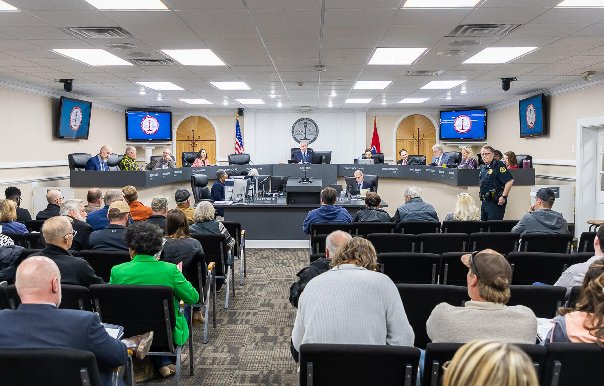

CLARKSVILLE, TN (CLARKSVILLE NOW) – A proposed rezoning of 1 acre north of West Concord Drive from R-2 single family residential to R-4 multiple family residential drew several concerns from City Council members, including potential flooding and traffic dangers.
Clarksville-Montgomery County Regional Planning Director Jeffery Tyndall introduced the proposal to the City Council and said it’s an application of Reda Homebuilders, and the zone change would be an extension of the existing R-4 to the east and south. Tyndall said the 1 acre is comprised of two residential lots with tall grass and a level building pad at the street level, but the rear of the property drops off into a flood zone.
“This is in the Lafayette Peachers Mill Planning Area, and the applicant’s statement is simply future building,” Tyndall said. “As I mentioned, there is a flood zone. So, what you’re looking at here, the dark blue is the floodway, that’s the ‘always floods.’ Then the lighter blue is the 100-year flood (plain) – the 1% annually of flooding.”
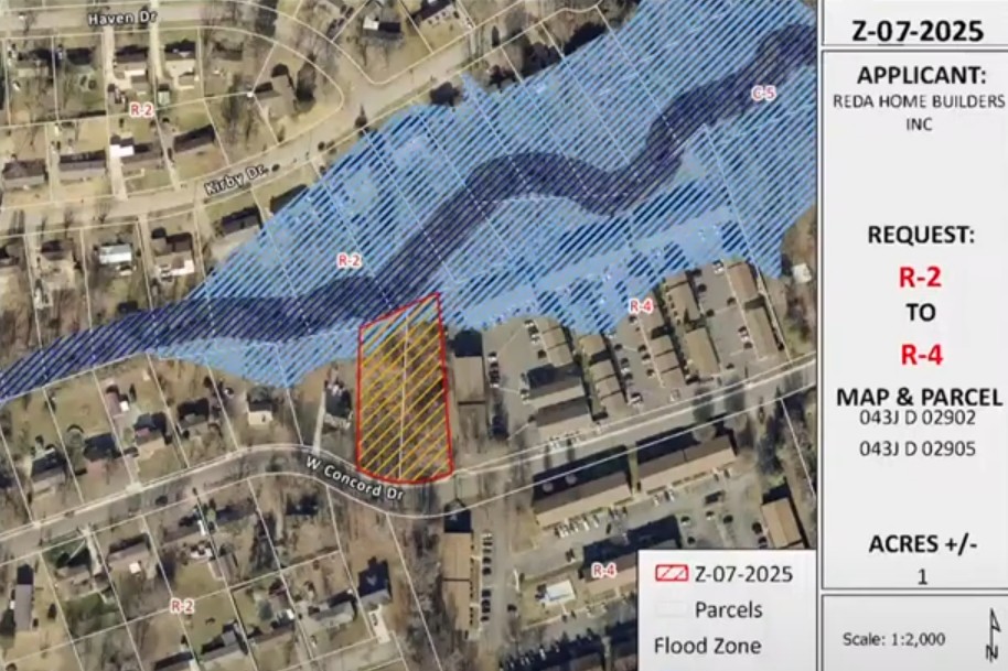
The Clarksville Street Department said the lot is impacted by the FEMA flood zone, and the applicant must maintain existing drainage way easements from West Concord on lot 2 and construct ADA-compliant driveway aprons and connect them to existing sidewalks.
Tyndall said historic estimates would be 12 units on this property, however, that figure may be a little high due to the loss of some land from the flood plain. While the rear portion of these two parcels falls within the flood plain, there remains adequate buildable area, unaffected by these incumbrances, Tyndall said. Engineering data will be required before development to ensure there are no adverse impacts to surrounding properties or the conditions of the floodway.
RPC staff recommended approval due to its consistencies with the goals and objectives of the Comprehensive Plan. The Planning Commission recommended approval as well.
| NEWS ALERTS: To get free breaking news alerts on your phone, text the word NEWS to 43414.
‘I’m talking about inside the living spaces’
Councilperson Deanna McLaughlin said prior to Feb. 15, there was no reason for her to be against the proposed zone change. However, on Feb. 15, houses on both sides of the drainage ditch in the area, along with three apartment complexes, flooded when they had never flooded before.
“I’m not talking about backyards, fences, sheds. I’m talking about inside the living spaces,” McLaughlin said. “I’m not an engineer, but I did draw some lines on the map the Planning Commission had in the packet of where the drainage water comes from in this area. If you start at Dover Road, anything west travels all the way through the ward, and the flood area that’s a designated wetland, and Donna Drive, also connects to it and chokes at this point here.
“The water travels from all directions, comes along that drainage ditch between Kirby and Concord, and goes under Fort Campbell Boulevard and then floods Councilman (Tim) Chandler’s ward. I’m not saying no forever, I just would prefer that we either keep it the current zoning of R-2, or we wait and maybe visit again the multi-family residential.”
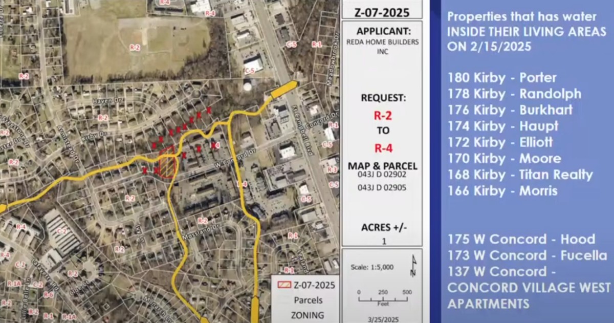
McLaughlin’s presentation said eight properties experienced flooding inside their living areas on Kirby Drive on Feb. 15, as well as three properties on West Concord Drive and the Concord Village West Apartments. She said residents are still trying to rebuild the parts of their property that had been damaged by the water, without knowing if it will happen again.
“The concern that I have is not only for the people that might live there once these are done, but where that water at the higher level is going to go once there are structures built there,” McLaughlin said. “There was a petition passed out at the Planning Commission meeting. … It has over 100 signatures of people who live on that drainage ditch that are asking ‘Please just keep it R-2.'”
She then asked for her fellow council members to vote down the request next week, as she believes it would not be responsible of the City Council to put more units there for the time being.
‘I’m a no now and probably a no forever’
Councilpersons Keri Lovato and Tim Chandler both said they have a hard time voting in favor of the proposal. Lovato asked Street Department Director David Smith if the floods from Feb. 15 exceeded the 100-year flood plain, which he confirmed.
| DON’T MISS A STORY: Sign up for the free daily Clarksville Now email newsletter
“Here’s my concern, and I appreciate the councilperson from Ward 2 giving grace to the developer and saying, ‘No but maybe in the future.’ But there’s no solution to a (FEMA) 100-year flood that has been shared with us,” Lovato said. “So, my question is, and it’s really a rhetorical one, is it appropriate to put any houses on this property when we know it’s a 100-year flood zone, we know it’s going to collect water, and we know those lines are extending. What are we doing to future residents that might be living in the homes that could potentially go there?”
Lovato said she is a no vote now and probably forever.
Additional infrastructure concerns
Councilperson Stacey Streetman said three people spoke in opposition of the zone change at the Regional Planning Commission and another concern was that of the S-curve in the area.
“This is located right in the S-curve, that was something else that I really paid attention to,” Streetman said. “I would anticipate that they’ll be here as well next week to speak on this, but they went through a list of accidents that had happened right in that area. One of the things I asked the Street Department, and of course it was no different than the answer we received earlier, those things will be addressed and dealt with at the site plan level.
“However, I see no other way than to have an entrance from this area going directly into the excess going to that S-curve. That does create some concerns for me as well,” Streetman said.
McLaughlin listed several examples of the accidents that have taken place on the S-curve, including a teenager being clipped by a car, fire hydrants being run over and a truck getting stuck in the drainage ditch. The residents who brought these concerns forward reported 14 accidents there, according to McLaughlin.
The City Council will take up and vote on the zoning change at their regular session meeting on Thursday, April 3, at 6 p.m.
| DOWNLOAD THE APP: Sign up for our free Clarksville Now app