
Updated with additional information on third variance.
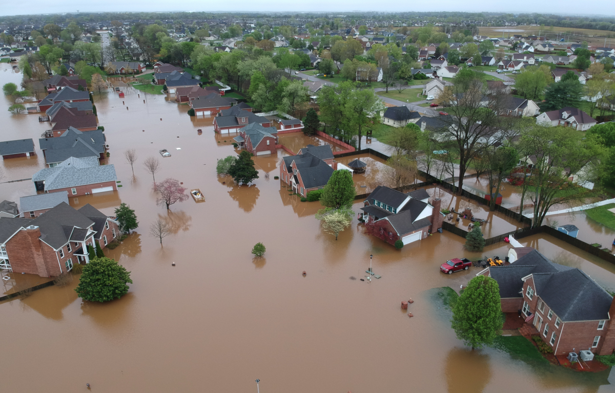
CLARKSVILLE, TN (CLARKSVILLE NOW) – Fifteen years ago in May 2010, a monsoon of rain submerged Riverside Drive downtown, low-lying Clarksville neighborhoods and, strangely enough, a new subdivision near the state line, miles away from the nearest creek or river: Woodstock Estates. Then it flooded again a year later.
Studies and possible solutions to the neighborhood’s flooding commenced, and for nearly a decade, Woodstock managed to stay afloat. But near the 15th anniversary of the flood of 2010, on the week of April 6, Woodstock residents were once again wading through water to get to their homes, many of which were new to the neighborhood. And this came only two months after a prior flooding of the neighborhood in February.

“Some of our neighbors have said they aren’t coming back,” said Roger Pearson, a five-year Woodstock resident. “This place is going to end up being a ghost town.”
Like Pearson, many residents are left with the same questions: Why is their neighborhood flooding? How was it allowed to be built? And what will it take to fix it once and for all?
Farmland to subdivision: ‘Concerns of drainage’
Before there were sidewalks and streetlamps in the area, Woodstock Estates was farmland belonging to Clarksville Properties, a company jointly owned by Jeff Burkhart (now a state representative) and Paul Cooper Sr. Burkhart held 25% ownership, while Cooper Sr. held 75%. According to 30-year Woodstock resident Carol Berry, for many years prior, that land was used for agricultural purposes, specifically pig farming and cornfields.
According to zoning documents obtained by Clarksville Now, in the fall of 1994, Clarksville Properties submitted an application to the Clarksville-Montgomery County Regional Planning Commission (RPC) requesting rezoning for 131.37 acres in the east margin of Trenton Road, just north of the Tylertown Road intersection, from agricultural to residential.
During the staff review in December that year, it was noted that “care will have to be taken with drainage as site contains a large drainage basin.” The RPC staff recommended approval. It was noted, however, that there was a concern about drainage and adequate water service. According to a copy of the zoning documents, the Montgomery County Commission approved this rezoning on Jan 9, 1995. At the time, Woodstock was outside the Clarksville city limits.
Flood plain variances granted
With the rezoning approved, individual construction companies lined up to buy pieces of the land to build homes on. In 1995 and 1996, the first 31 homes began hitting the market from developers including Burkhart and MJ Phillips.
Along the way, Burkhart needed a variance to build a portion of Woodstock Drive near the flood plain. He requested the variance from the RPC, and it was granted:
- Dec. 21, 1995 for Section 2 of Woodstock Drive, affecting 19 lots, to be built less than 2 feet above the 100-year flood line, the standard minimum at the time.
The city annexed the subdivision in 1997. After that, Woodstock Court and the remainder of lower Woodstock received site approval, and those areas would later be the most impacted by flooding. In order to continue construction on the final two sections of Woodstock, Burkhart, with Clarksville Properties, applied for two more RPC variances to build two roads, which the RPC granted:
- In 1997-98 for Section 3 (northern portion) of North Woodstock Drive and Woodstock Court, affecting 35 lots, to be built less than 2 feet above the 100-year flood line.
- In 2004-05 for Section 4 (southern portion) of North Woodstock Drive, affecting 14 lots, for an excessive cul-de-sac length.
RPC documents obtained by Clarksville Now include notes labeled “Jack” in January and March 1998 stating that the roads are not 2 feet above the flood line, and that the cul-de-sac is even with the flood plain. Then, a note dated April 21, 1998, says, “Mike Frost (then-Montgomery County Highway Supervisor) knew @ the time the road plans were approved that portion of road was not going to be 2′ above 100 yr.”
A memo follows from Jack Frazier, then-Clarksville City Engineer, on the subdivision plans being ready for the RPC, pending the variances being approved.
“I would not recommend that we approve that type of variance today,” Jeff Tyndall, current RPC director, told Clarksville Now, referring to the flood line variance. “Regardless of why it happened … a variance isn’t to make up for a mistake, it’s typically supposed to be due to the unique situation that that specific piece of land has, and building a road below minimum height is what we call a self-imposed hardship.”
Tyndall explained that the purpose of the variance wasn’t because the land was too high or too low, but that, “The variance avoided having somebody go back and make a very expensive fix. There’s nothing unique to that property (Woodstock) that would make that variance, for a brand-new road, necessary.”
Clarksville Now has reached out to Burkhart and to Cooper for comment.
| DOWNLOAD THE APP: Sign up for our free Clarksville Now app
From 2000-2005, developers including Burkhart, Downs Custom Homes, Milam Construction and James McGregor built up Woodstock Court. In 2006, attention was turned to the southern half of the neighborhood. Downs Custom Homes led the charge on construction of 13 properties around the southern portion Woodstock Drive cul-de-sac, and, in 2008, the final home was built by Special T Homes.
Clarksville Now has reached out to or attempted to contact all of the developers involved.
Flood of 2010 and 2011 encore
In the spring of 2010, a rainy weekend in Clarksville took a surprising turn. From May 1-2, Clarksville was hit with storms that accumulated a record-breaking 11 inches of rainfall. The Cumberland and Red Rivers rose, submerging Riverside Drive downtown and other low-lying areas.
Since then, locals have taken to calling it “The Great Flood of 2010,” with a lesser-used alias: “The 100-Year Flood.” According to the Federal Emergency Management Agency (FEMA), a 100-Year Flood is a flood event that has a 1% chance of occurring every year based on statistics of past flood events.
Perhaps the most puzzling situation in the midst of the 2010 disaster was the sudden lake that formed at Woodstock Estates, over 2 miles from the nearest river point, as the crow flies. While residents despaired over the damages to their homes, city and county officials dove in to the investigate the cause.
| NEWS TIPS: Do you have a local news tip? Email news@clarksvillenow.com or call us at 931-648-7720.
However, nearly one year later, Mother Nature celebrated the anniversary with an encore. According to Leaf-Chronicle archives and the National Centers for Environmental Information, from April 26-28, 2011, Clarksville was hit with roughly 5 inches of rain. Though it was significantly less than 2010, and Riverside Drive stayed above the water level, Woodstock residents saw their streets and homes flooded once more.

Failed fixes, unfinished plans
In the wake of those disasters, city officials worked on fixes and solutions. According to Leaf-Chronicle archives at the time, the root of the problem was just across the state line. A sinkhole on a farm in Kentucky directly north of Woodstock normally took in excess water, and when it didn’t, surface drainage basins around Woodstock helped store the runoff, but those overflowed from huge rains in 2010 and 2011.
By October 2011, City of Clarksville engineers proposed a two-phase plan that could solve the issue. First, dig out the drainage basins at Woodstock to allow for more water. Second, install an overflow pipe at the southwest corner of the neighborhood to allow the water to flow under Trenton Road and into a new water retention basin.
| DON’T MISS A STORY: Sign up for the free daily Clarksville Now email newsletter
But the city did not own the land for either half of the plan. They would have to buy it from Clarksville Properties. It was a controversial 2011 City Council move that narrowly passed, with Clarksville Properties co-owner Burkhart, sitting on the council at the time, abstaining from the vote. To further separate himself from the decision, Burkhart agreed that money spent by the city to purchase the land would go directly to the Paul Cooper Sr. family.
Despite purchasing a plot of land nearly half a mile from Woodstock near a Waste Transfer facility in 2014 and receiving studies and reports from Gresham Smith in 2011 and in 2019, the overflow drainage pipe remained a pipedream.
City officials told Clarksville Now that the subsequent phase of the project – to directly pipe and channel the water – was never completed. It would have involved the purchase of land from adjacent property owners. The previous administration worked on acquiring the necessary land but could not come to an agreement, and the administration chose not to pursue condemnation.

What’s next for Woodstock
While the previous pipe solution was never implemented, other fixes are now being considered. “This project is separate from our two potential solutions, along with the discussed deepening of the existing basin, all of which are intended to address our current, much higher, level of precipitation,” the city said in response to Clarksville Now questions.
The two options the city mentioned have the same goal, just different locations: capture the water (much like a sewer system) through a storm force main and pump it into areas that can handle it. The best areas to receive that excess water are tributaries of the Red River. Currently, the city is considering two destinations for the water:
- Option 1: West Fork of the Red River. This option would pump the water west alongside the back of Waste Connections on Tylertown Road and then run under Interstate 24 to just north of a nearby subdivision. This option pushes the water to the state line and into the Big West Fork Creek, where it would channel south into Clarksville. This solution would need to be metered to make sure that this excess water does not flood unique areas (areas that currently don’t experience flooding.)
- Option 2: Spring Creek. This option would pump the water south toward Tylertown Road, where road widening is currently ongoing. Similar to the first option, this method would pump the excess water into an existing tributary, Spring Creek, which flows into West Fork, then into the Red.
During the Woodstock neighborhood meeting in April, David Smith, director of the Clarksville Street Department, explained that both of these options create their own challenges, and city engineers are currently vetting the outfall areas to make sure they can handle the additional water. They are also assessing costs.
Additionally, the city is looking into whether they can excavate the current basin in Woodstock to build out temporary capacity in order to hold the excess water long enough for these future pumps to be put into operation.
Woodstock timeline
Here is a timeline of key events leading up to this year’s floods:
- Fall 1994: Clarksville Properties seeks rezoning for 131.37 acres from agricultural to residential.
- January 1995: Montgomery County Commission approves rezoning.
- April 1995: Clarksville Properties begins transferring lot deeds to developers, building permits are obtained.
- 1995-96: First 31 homes in Woodstock Estates hit market.
- November 1997: Woodstock annexed into City of Clarksville.
- April 1998: Subdivision plans approved with variance for North Woodstock Drive and part of Woodstock Court to be built less than 2 feet above 100-year flood elevation.
- 2000-05: Woodstock Court developed.
- May 2004: Plat approval of Woodstock Estates Section 4, with variance for excessive cul-de-sac length of Woodstock Drive.
- 2006: Construction begins on southern portion including 13 properties around Woodstock Drive.
- 2008: Final home, lot 77, is built.
- May 2010: Woodstock floods during the Flood of 2010.
- April 2011: Woodstock floods again.
- October 2011: City brings in Gresham Smith as consultant to conduct studies.
- 2014: City purchases small plot half-a-mile from Woodstock to implement overflow pipe solution. Never completed.
- February 2025: Woodstock floods.
- April 2025: Woodstock floods again.

‘Gambling with homes and well-being’
Woodstock residents Sharon and Roger Pearson understand that the solutions will take time and a great expense. But the alternative – leaving residents vulnerable to repeat, catastrophic flooding – is far more costly in terms of property damage, displacement and community safety.
“The city appears to be prioritizing budget concerns over resident safety, essentially gambling with our homes and well-being,” Sharon told Clarksville Now. “Long-term solutions cannot excuse short-term negligence.”
Sharon said her husband Roger got ill after working in the flood waters. They, along with a neighbor in her 80s, still haven’t been able to return to their homes two months after the flood. Additionally, one of their elderly neighbors is now in a nursing home after the stress of the flood escalated her dementia.
“We feel vulnerable, and we just don’t know what to expect,” Sharon said. “The city has offered no help to us. They’re just leaving us at risk. I get it, it takes time, but they need to really be thinking about our safety and our homes. This is our life.”
Sharon says that the city needs to have something ready now in case this happens again. As of May 28, the basin in Woodstock is full, there is still standing water in Kentucky, and, if the neighborhood gets any more rain, Sharon said there won’t be anywhere for it to go.
“If we get back in our home, are we going to be there a week, two weeks or a month before it happens again?”
PREVIOUSLY:
- Clarksville at 245% over normal annual rainfall, city considers ‘very expensive’ flooding solutions
- ‘There ain’t any money left’: Military couple depletes retirement to recover from Woodstock flooding
- ‘Here we go again’: Homeowners say they were told Woodstock flooding was fixed | PHOTOS
- ‘We don’t want personal conversations’: Clarksville officials meet with Woodstock flood victims